Basic HTML Version


13
PROTECTED NATURAL HERITAGE
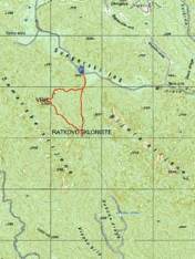
From the car parking area under the rocks of Samarske stijene
(the area is called 13. kilometar) follow the marked path
towards Ratko’s shelter. From there, return to the last crossing
(5 minutes) and turn left for the peak of Samarske stijene.
Beneath the peak you will see the turning to the right that you
should use on the way back. From the peak, the path leads
steeply downhill (at the crossing after the steep part continue
straight on) until you reach the exit to the forest road. After
some twenty minutes of moderate walking, the road will bring
you back to the car parking area.
Recommended tour from the starting point
Length of the tour:
Walking time:
Difficulty:
Maps of the area:
5.2 km
2 hours and 30 minutes
demanding
SMAND 11a hiking map,
Samarske i Bijele stijene,
Bjelolasica, SMAND hiking
map, Gorski kotar GPP
- Goranski planinarski put
(Gorski kotar Hiking Trail)
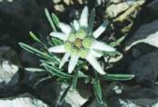
The rocks of Bijele stijene and Samarske stijene
are the only strict reserve in the County of
Primorje-Gorski kotar. It is the area with the
strictest protection regime, therefore we kindly
ask visitors not to damage or endanger the
untouched primordial nature of the reserve.
Mrkopalj
900
900
1100
1100
1200
1200
1000
1000
950
950
1300
1300
1250
1250
1150
1150
1050
1050
Elevation profile of the tour