Basic HTML Version


15
PROTECTED NATURAL HERITAGE
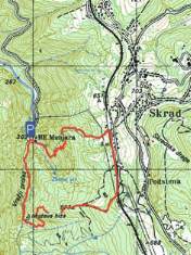
Length of the tour:
Walking time:
Difficulty:
Maps of the area:
4.6 km
2 hours
medium demanding
SMAND hiking map
Gorski kotar GPP-Goranski
planinarski put
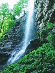
From the car parking area follow the marked path to the
Zeleni vir waterfall, and then take the steep, winding path
towards Skrad (train station). Follow the railway track
southwards up to the crossing with a gravel road. Use that
road to head downhill and follow the marked path to reach
the canyon (Muževa hiža cave) and continue through Vražji
prolaz canyon back to the car parking area.
Recommended tour from the starting point
Elevation profile of the tour