Basic HTML Version


21
PROTECTED NATURAL HERITAGE
Elevation profile of the tour
Length of the tour:
Walking time:
Difficulty:
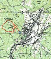
Maps of the area:
4.3 km
1 hour and 30 minutes
easy
SMAND hiking map,
Gorski kotar GPP- Goranski
planinarski put
At the car parking area near Lovački dom, take the path to
the nearby ski jump, which offers a magnificent view of the
town of Delnice. Continue straight ahead on the maintained
marked path up to the turning for the peak. There, turn left
and follow the bends uphill until you reach the top. On your
way back, it takes several minutes from the top to reach the
first intersection, then turn right and continue downhill until
you reach a gravel road (along the logging track, straight
on). Follow the markings right to the Pijaničevo area and
continue on a well-maintained path to Lovački dom (car
parking area).
Recommended tour from the starting point