Basic HTML Version


25
The old regional road that connects the counties of Primorje-
Gorski kotar and Istria passes through the Učka Nature Park;
take this road and follow the brown signs to reach the Park
from the direction of Matulji.
Alternatively, you can take the motorway that starts in Matulji,
passes through Učka Tunnel and continues to the Istrian Y
motorway. If you choose this route, then leave the motorway
before the tunnel at the exit for Veprinac and follow the brown
signs pointing you towards the Učka Nature Park.
Access and starting point
Length of the tour:
Walking time:
Difficulty:
Maps of the area:
7 km
4 hours
medium difficulty
tourist geographical map of
the Učka Nature Park
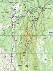
The tour starts on Poklon, a mountain pass that connects the massifs of Učka and Ćićarija and includes the Poklon mountain
hut, the Učka pension and the Učka Nature Park information kiosk and souvenir shop. From Poklon, set off towards Učka’s
highest peak, Vojak, through a littoral beech forest following the markings and signposts. Once you reach Vojak, you can enjoy
a very attractive panoramic view of the surrounding landscape. In addition to being a magnet for numerous climbers and hikers,
Vojak has recently become very popular among paragliding and hang-gliding enthusiasts. On the way back down the asphalt
road, after some five hundred metres you will reach a display board inviting visitors to take the well-tended Plas educational trail
through the forest with several belvederes, places to rest and interpretation boards explaining more about the plant and animal
species that inhabit the peak areas of Učka. The Plas educational trail is connected to the trail that leads to Poklon.
Recommended tour from the starting point
PROTECTED NATURAL HERITAGE
Opatija
1000
2000
3000
6000
4000
5000
7000
950
1050
1150
1250
1350
850
750
950
1050
1150
1250
1350
850
750
Presjek visina obilaska
El vation profile of the tour