Basic HTML Version


45
PROTECTED NATURAL HERITAGE
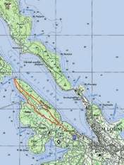
Near the monument to the fallen soldiers of World War Two,
take the marked path and continue straight on, following
the signs for the peak of Vela straža. After the peak, the path
descends to the left and connects with a wider path that leads
straight to the cape of Boka falsa. From the cape, return by the
footpath along the southern part of the peninsula to the cove
of Slatina. Continue across the meadow into the forest and
follow the signs for Mali Lošinj and back to the monument.
For most of this, the tour passes along some beautiful dry-
stone walls.
Recommended tour from the starting point
Length of the tour:
Walking time:
Difficulty:
Maps of the area:
5.5 km
1 hour and 30 minutes
easy
Mali Lošinj Tourist map
(footpaths and hiking trails)
Elevation profile of the tour