Basic HTML Version


restaurant, toilets and washroom, workshop, 10
ton crane, a slipway. There are no fuelling
facilities here.
In the morning, or if we have decided not to loiter
on the sandy beaches of the north-western part of
Rab, rounding Kalifront Point we continue
towards the south. Kanitalj Point is located in the
middle between a lot of bays that have bitten
deeply into the western part of Rab. When we
catch sight of Frkanj Point, the end of which is
marked by a red lighthouse, that is a sign that we
have sailed almost as far as Rab Town.
The island of Rab is often compared with the
denizens of the deep. For example, its outline on
the chart recalls a lobster. Stojan and Kalifront
points are its claws… Another time it might be
described as a squid, and then Prvi , Grgur and
Goli, islands that are located to the north of it, are
the ink blots it has voided in its flight from hungry
Krk (a conger, presumably). But no plan of any
island can represent the true picture of it. For,
quite simply, a sailor is not a bird.
Sailors distinguish islands by their scents, colour,
the depth of the coasts, recall them by the taste of
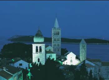
the wine from their climes. And Rab, Rab Town,
has to stick in a yachtsman's memory for the
number of its towers. For the sweet harmony of the
sound of their bells.
This ought to cause no great surprise, for John
Baptist of Rab, year of birth not precisely
determined, died 1540, was a true master bell
founder. He cast his greatest bell in 1506 in
Dubrovnik, and it weighedmore than two tons. Of
course, the kings and princes of the time also
made use of bell-founders, for the same skills went
into themaking of cannon.
But alas, flicking over the pages of the rich history
of Rab, one part of it will remain absent the smell
of the mulberry, for silk was being produced on
Rab when it was still unknown elsewhere in the
West.
One can sail into Rab harbour by navigating
between Frkanj Point, on which there is a red
lighthouse (C Bl 2s 5m4M) and the Frkanj shoals,
marked by a green light on a concrete base (Z Bl 2s
2m 4M). For people with GPS, the exact position
of the shoals is N 44 44.49, E 14 45.59. You can
also sail round the shoals from the south-eastern
side. The entrance into the harbour itself is
marked with a red lighthouse on Sv. Ante Point (C
Bl 1.5s 7m 3M) and a green lighthouse on Tuner
islet (Y Bl 2s 14m 4M). Because of the shoals in
æ
Rab