 |
 |
 Opatija Riviera Opatija Riviera
Rijeka and surroundings
Crikvenica Riviera
Riviera di
Novi Vinodolski
> Island of Lošinj
Island of Krk
Island of Cres
Island of Rab
Gorski
kotar


|
 |
THE ISLAND OF LOŠINJ · A Route with Beatiful Views
The Lošinj route is primarily intended for mountain bikers, and it is possible to combine it for more experienced bikers as well as beginners.
We start from the waterfront of the island of Mali Lošinj in the direction of Premuđa, arrive at a gasoline station (0.5 km), and continue
straight. At 1.27 km, we turn right on a macadam road, which we take through a former military complex. We then continue along a stone
path to Zlatna, Srebrena Uvala, via Čikat and Sunčana Uvala, to the Borik Restaurant (11.2 km), where we turn left toward the Hotel Vespera,
which we pass and then turn right at 11.8 km. At 13.0 km, less experienced cyclists can turn off toward the center of Mali Lošinj. We turn
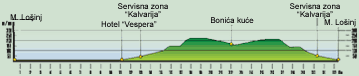
right at 13.6 km and at 13.8 km take another right. We pass through the Kalvarija Service Zone, where we begin our ascent on a macadam
road. At 15.2 km, we turn right and at 15.9 km we continue straight on a demanding macadam road toward the Bonia Houses (21.7 km).
We can continue by bicycle until 22.3 km. Here we have a magnificent view of the island of Ilovik. We turn around and take the same route
to an asphalt road (30.2 km). At the crossroads (31.0 km), we turn left and at 31.8 km right on Versikovo Street. After 200 m, we turn right
and go down some stairs to the waterfront (32.3 km).
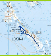 |
LOCATION: Island of Lošinj
DEPARTURE: Mali Lošinj, 0 m above sea level
GOAL:
Mali Lošinj, 0 m above sea level
LENGTH: 32,3 km
ALTITUDE DIFERENTIAL: 220 m
HIGHEST POINT: 220 m
ACCESSIBILITY BY BICYCLE: TOTAL
DIFFICULTY: MODERATE (BLUE)
TIME NEEDED: 2 hours, 30 minutes |
|
|