 |
 |
 Opatija Riviera Opatija Riviera
> Rijeka area
Crikvenica Riviera
Novi Vinodolski Riviera
Island of Lošinj
Island of
Krk
Island of
Cres
Island of
Rab
Gorski
kotar


|
 |
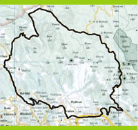
AROUND THE SOURCE OF THE RJEÈINA RIVER - Alpine Air Near the Sea
In Saršoni, we turn left in front of the park toward Klana, and continue straight at Pogled (2.6 km). At the crossroads for Studena (3.5 km)
and the crossroads for Breza (6.75 km), we continue straight. At 7.0 km, we turn right toward Klana. In the center, we continue straight and
at 9.0 km we turn right, following the sign toward the sawmill (11.0 km), after which we begin our ascent. We reach a macadam road (12.7
km), on which we continue straight. At 13.0 km, we turn right and arrive at a spring of potable water (13.4 km). We gradually descend
toward Mlake, after which we start climbing again. At 18.4 km, we continue straight, and at 19.0 km we continue straight. At the top of our
ascent, we pass through a tunnel (20.15 km), and arrive at the Gumance Plateau. At 21.9 km, we turn right, and at an abandoned house at
24.6 km we turn right again. At the end of the Trstenik Plain, we turn left (to our right is a spring of potable water). We enter Suho (27.9
km), where there are several abandoned houses. At the crossroads, we continue straight ahead. At 31.6 km, we turn right and after 200 m,
we follow the right bend in the road. At 35.2 km, 36.2 km and 37.8 km, we go straight to 39.0 km, where an asphalt road begins that takes
us to Platak Dom (40.1 km). At 41.0 km, we continue straight past a house, and at 46.2 km we continue straight and arrive at the Rijeka-
Gornje Jelenje Road (49.3 km). We turn right in the direction of Rijeka and descend to Grobničko polje (56.0 km). At the highway (56.7 km),
we continue straight to a monument (58.5 km), where we turn right. In the village of Podhum (59.7 km), we go left and arrive at the Vlačina
Pizzeria (60.6 km). Here we turn right toward (Dražice (61.5 km), where at 62.4 km we continue straight, and after 200 m turn left toward
Donje Jelenje (63.5 km). At 64.0 km, we turn left and arrive at Ratulje (64.5 km), then Lubarska (65.0 km), and after 150 m we go straight
to Brnelić (65.8 km). At 67.0 km, we go left to the bridge across the Rijeèina River, pass through Trnovica, and ascend to the top of Lončeva
Griža (70.9 km), from which we descend to Saršoni (71.7 km).
 |
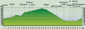
LOCATION: Klana - Platak
DEPARTURE: Saršoni 450 m above sea level
GOAL: Saršoni 450 above sea level
LENGTH: 71,7 km
ALTITUDE DIFERENTIAL: 840 m
HIGHEST POINT: 1120 m
ACCESSIBILITY BY BICYCLE: TOTAL
DIFFICULTY: DIFFICULT (BLACK)
TIME NEEDED: 5 hours, 30 minutes |
|
|