 |
 |
 Opatija Riviera Opatija Riviera
Rijeka and surroundings
Crikvenica Riviera
Novi Vinodolski Riviera
Island of Lošinj
Island of
Krk
> Island of
Cres
Island of
Rab
Gorski
kotar


|
|
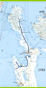
THE CENTRAL AREA OF THE ISLAND OF CRES
The Cres mountain bike path begins at the Cres marina. From the reception area, behind the marina
barrier, we arrive at the Cres water supply system. We begin our ascent and turn right at 0.75 km. We
climb to 2.5 km, and at 2.8 km continue straight and take a macadam road up and down several little
hills. On the path, we encounter wooden hurdle gates used to prevent attacks from sheep. After you
pass, be sure to close the gate behind you. At 12.5 km, we reach an asphalt road that leads toward
Valun. However after 0.5 km, we turn left toward Pernat, and right at 13.3 km. We arrive in Zbièina
(14.6 km) and continue through a field on an asphalt road to Pernat (17.5 km). By the same route, we
return toward Valun. At 21.5 km, we turn right and arrive in Podol (24.0 km). In the village, we turn
left and then right toward Lubenice, which we reach after a steep climb (27.3 km). We return by the
same route. At 30.9 km, we turn left, again pass through Podol, and turn off at Valun at 33.9 km. We
descend to the Valun waterfront. From Valun, we ascend on the road we came by and at 38.0 km we
are again on the macadam road we took when we left Cres. We arrive in Cres after 50.5 km.
 |
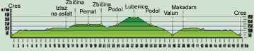
LOCATION: Island of Cres
DEPARTURE: Island of Cres, 0 m
above sea level
GOAL: Island of Cres, 0 m above
sea level
LENGTH: 50.5 km
ALTITUDE DIFFERENTIAL: 380 m
HIGHEST POINT: 380 m
ACCESSIBILITY BY BICYCLE: TOTAL
DIFFICULTY: MODERATE (BLUE)
TIME NEEDED: 3 hours, 30 minutes |
|
|