 |
 |
 Opatija Riviera Opatija Riviera
Rijeka and surroundings
Crikvenica Riviera
Riviera di
Novi Vinodolski
Island of Lošinj
> Island of Krk
Island of Cres
Island of Rab
Gorski
kotar


|
 |
THE CENTRAL PARK OF THE ISLAND OF KRK · A World of Shepherds and Farmers
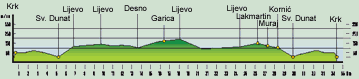
From Forum, the central square in the city of Krk, we ride uphill toward the road to Punat. After 500 m, we
arrive at a crossroads and turn right. After 5.2 km, we arrive at Sv. Donat, passing by a small Old Christian
church, and continue straight up a somewhat steeper slope in the direction of Ba[ka. At 6.8 km, we turn left
in the direction of ©ilo-Vrbnik. At 9.7 km, we turn left from the main road to a side road and pass through
fields and meadows, bordered by old stone walls. At 13.6 km, we turn right and at 15.8 km we are below
the village of Garica and make a right turn. At the entrance to Garica, we turn left. After leaving the village,
we continue straight in the direction of Krk. Just prior to the exit to the Omi[alj-Krk Road, we turn left at
24.3 km in the direction of Korniæ. We arrive at the village of Lakmartin (26.2 km), where we turn left at
26.4 km, and arrive in Muraj (27.2 km). In Muraj at 27.5 km, we turn left in the direction of Korniæ, where
we arrive at 28.3 km. From Korniæ, we descend a steep slope to Sv. Donat (29.9 km) and return by the same
road we traveled when we left Krk to our starting point (34.4 km).
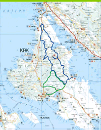 |
LOCATION: Island of Krk
DEPARTURE: Krk, 0 m above
sea level
GOAL: Krk, 0 m above sea level
LENGTH: 34,4 km
ALTITUDE DIFFERENTIAL: 190 m
HIGHEST POINT: 190 m
ACCESSIBILITY BY BICYCLE: TOTAL
DIFFICULTY: EASY (GREEN)
TIME NEEDED: 2 hours |
|
|