 |
 |
 Opatija Riviera Opatija Riviera
Rijeka and surroundings
Crikvenica Riviera
Riviera di
Novi Vinodolski
Island of Lošinj
> Island of Krk
Island of Cres
Island of Rab
Gorski
kotar


|
 |
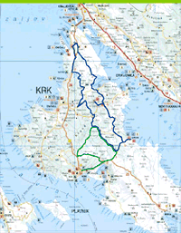
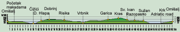
THE HILLS AND VALLEYS OF THE ISLAND OF KRK · An Adventure on the Golden Island
We depart on this interesting tour of Krk from Omišalj, in front of the church. We descend to the gasoline
station on the highway and turn right in the direction of Krk. After 2.7 km, we turn from the main road onto
a macadam road, by which we descend to 6.7 km, where we turn right and reach asphalt (9.0 km). We
continue right to Čižići, where we turn left at 10.0 km. At 10.7 km, we turn left again in the direction of
Klimno, ©ilo. At 11.6 km, we turn right and continue uphill to D. Hlapa, where we continue straight (13.2
km) across G. Hlapa in the direction of Dobrinj. We pass through Sveti Vid Dobrinjski and descend briefly
to the town of Dobrinj, where we have a beautiful view of the surroundings from the churchyard. We
return by the same route to 18.4 km and turn right at Gostinjac, in the direction of Vrbnik and Risika, where
we arrive after 21.8 km. In the center (22.1 km), we go uphill to the right and gradually enter Vrbničko
Polje, where at 25.1 km we turn left and descend to the town of Vrbnik. From Vrbnik, we climb the same
route to Vrbničko Polje, where we turn left at 30.0 km. After a climb, at 31.6 km we turn right and follow
the road along a meadow. At 35.5 km, we turn right and at 37.6 km turn right again toward Garica. Upon
leaving the village, at 40.0 km we turn right in the direction of ©ilo and arrive in the village of Kras (41.7
km). At 42.5 km, we turn right and at 42.9 km we turn left on a macadam road, by which we descend until
Sv. Ivan Dobrinski (45.0 km). At the entrance to the main road (45.9 km), we turn left in the direction of
Malinska and arrive at the village of Rasopasno. In the village, we turn right at 47.6 km on a macadam road.
At 49.0 km, we turn left and arrive at the village of Sužan (51.0 km). At the church, we turn left. Immediately
after 30 m, we turn right on an old village road. We go down a steep slope toward a field and ride through
it. We turn left at 53.2 km, right at 54.7 km, left at 54.9 km and left again at 56.1 km. At 57.6 km, we exit
onto the Krk Highway across from the entrance to Njivice. We turn right in the direction of Omišalj, left
after 2 km and climb uphill to Omišalj (62.1 km), from where we departed.
 |
LOCATION: Island of Krk
DEPARTURE: Omi¹alj, 100 m above sea level
GOAL:
Omi¹alj, 100 m above sea level
LENGTH: 62.1 km
ALTITUDE DIFFERENTIAL: 260 m
HIGHEST POINT: 260 m
ACCESSIBILITY BY BICYCLE: TOTAL
DIFFICULTY: MODERATE (BLUE)
TIME NEEDED: 4 hours, 30 minutes |
|
|