 |
 |
 Opatija Riviera Opatija Riviera
Rijeka and surroundings
Crikvenica Riviera
Riviera di
Novi Vinodolski
Island of Lošinj
Island of Krk
Island of Cres
Island of Rab
> Gorski
kotar


|
 |
FORESTS OF GORSKI KOTAR
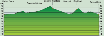
From the center of Ravna Gora (in front of the Radin Factory), we set off toward Stara Su[ica. After 0.2 km, we turn right. At 5.5 km, we turn
left on a macadam road and begin a gradual ascent. At 8.7 km, we continue straight, at 9.5 km we turn right, and at 11.7 km continue
straight. At 14.0 km, we turn right at Begova Cisterna. At 14.6 km, we arrive at a crossroads and make a half right turn, following the signs
for cyclists. We can also turn left and at approximately 7 km reach the Bjelolasica Olympic Center. We make a half right turn and continue
until 15.1 km, when we turn left (the sign for cyclists says right toward Lokanda - do not follow the sign). At 15.3 km, we turn right and
begin to climb. At 17.7 km, we turn right, at 18.6 km left, and at 20.0 km we are on a plateau, from which we begin to descend toward
Begovo Razdolje (21.0 km). We continue to descend via Mrkopalj (27.3 km), where at 27.9 km we turn right toward Stari Laz (31.0 km).
After several sharp hills, we arrive in Ravna Gora (40.0 km).
 |
LOCATION: Gorski kotar
DEPARTURE: Ravna Gora, 830 m above sea level
GOAL: Ravna Gora, 830 m above sea level
LENGTH: 40 km
ALTITUDE DIFFERENTIAL: 310 m
HIGHEST POINT: 1140 m
ACCESSIBILITY BY BICYCLE: COMPLETE
DIFFICULTY: MODERATE (BLUE)
TIME NEEDED: 2 hours, 30 minutes |
|
|