   |
|
    |
 |
|
  |
|
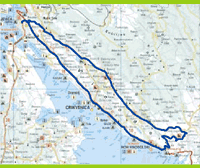
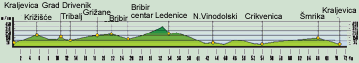
VISIT TO THE FRANKOPAN CASTLES (FRANKOPANSKI KAŠTEL) On this tour of the castles formerly owned by the Frankopan counts, we depart from one of their most representative buildings, the Kraljevica Castle. After 300 m, we turn left and continue our ascent toward the Jadranska Highway, where we turn right in the direction of Split. At 2.5 km, we turn left in the direction of Križišće (5.5 km), and at 5.8 km we turn toward Tribalj and Drivenik, where we arrive after 8.1 km. We ascend via Bla¹ković (16.7 km), reaching a spring of potable water at 17.1 km, and continue until Grižane (18.6 km), the birthplace of the famous artist Juraj Klović (Giulio Clovio). At 19.8 km, we turn left in the direction of Bribir, which we reach at 21.7 km. At 24.3 km, we turn left and arrive at the center (25.2 km), in which we turn left toward Ogulin. We pass by the villages of Kičeri and Ugrini, turn right at 28.3 km, and turn left at 29.4 km. At 32.5 km, we turn right and at 33.8 km we arrive at Ledenice and pass through the center. After 35.4 km, if we wish to visit the old castle, we turn left and take the macadam road. At 36.1 km, we pass through Donji Zagon. After 38.1 km, we turn left in the direction of Novi Vinodolski (41.4 km). At 42.4 km, we arrive at the Jadranska Highway, from which after 100 m we turn right toward the center and arrive at another Frankopan castle (43.1 km). Taking the same route, we return to the Jadranska Highway and turn right toward Crikvenica (52.3 km), where at 53.0 km we turn left toward the center. We arrive at a castle that has been made into a hotel at 53.7 km. We continue toward the center of Crikvenica, and at 56.3 km we are again at the Jadranska Highway. We pass Šmrika (66.0 km), and at 69.6 km turn toward Kraljevica, to which we return after a trip of 70.5 km.
|
|
||||
|
|
|||||||||
 THE KVARNER COUNTY TOURISM OFFICE 51410 Opatija, Nikole Tesle 2, tel: +385/51/272-988, fax: +385/51/272-909 http://www.kvarner.hr, e-mail:kvarner@kvarner.hr |
|||||||||