   |
|
    |
|
|
 |
|
 |
|
Ranko Starac ARCHAEOLOGICAL HERITAGE From flint axes to perun, the god of thunder 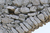 The
Kvarner area was inhabited by a few nomadic groups of hunters and
gatherers already in the late Palaeolithic, that is, at the end of the
last Ice Age. At that time, characterised by extremely cold winters and
arctic landscape, the sea level was significantly lower - the coastline
of the northern Adriatic ran between today’ s towns of Zadar and Ancona.
Half-caves and karst valleys (dolines), protected from cold northern
winds, provided shelter for the people who set traps, caught fish and
hunted game along the banks of numerous streams that flowed through the
tundra where today’ s islands of Kvarner lie. The most important human
habitats of that era were the karst valley of Jami na sredi and the cave
of Vela spilja on Mount Osoršćica on the island of Lošinj. The beginning
of a warmer climatic period after the glaciation saw the sea level rise
within a relatively short time, which resulted in the creation of a
landscape similar to the one we know today. As the sea advanced, many
types of wild animals retreated into the mountainous hinterlands, and in
the Mesolithic period nomad groups took shelter in the caves in the
mountains of Učka and Ćićarija, in the mountains of the Kastav region,
and also in Gorski kotar. The
Kvarner area was inhabited by a few nomadic groups of hunters and
gatherers already in the late Palaeolithic, that is, at the end of the
last Ice Age. At that time, characterised by extremely cold winters and
arctic landscape, the sea level was significantly lower - the coastline
of the northern Adriatic ran between today’ s towns of Zadar and Ancona.
Half-caves and karst valleys (dolines), protected from cold northern
winds, provided shelter for the people who set traps, caught fish and
hunted game along the banks of numerous streams that flowed through the
tundra where today’ s islands of Kvarner lie. The most important human
habitats of that era were the karst valley of Jami na sredi and the cave
of Vela spilja on Mount Osoršćica on the island of Lošinj. The beginning
of a warmer climatic period after the glaciation saw the sea level rise
within a relatively short time, which resulted in the creation of a
landscape similar to the one we know today. As the sea advanced, many
types of wild animals retreated into the mountainous hinterlands, and in
the Mesolithic period nomad groups took shelter in the caves in the
mountains of Učka and Ćićarija, in the mountains of the Kastav region,
and also in Gorski kotar. During the 6th millennium BC, the Kvarner islands were reached by groups of the so-called Impresso culture from the south-east Mediterranean area, who began making clay pots. This Mediterranean population mainly gathered plants, hunted, fished, made pottery and began the use of polished stone tools. In this period, some animals such as sheep, goats, cattle and pigs were already domesticated, and the settlements were guarded by dogs. The Neolithisation of the northern coastal area ended in the 4th millennium BC. The oldest open settlement discovered so far was founded in the late Neolithic Age on the south-west slope of Solin hill above the cove of Martinšćica. During the 3rd millennium BC, in the Bronze Age, the old Mediterranean population was driven away or assimilated in several waves of migration, and the region was conquered by warriors and cattle-breeders of Indo-European origin from the eastern parts of Europe. The early Bronze Age began around 2400 BC. The newcomers took possession of key locations and began the long process of constructing fortified hill-top settlements – the so-called hill forts (gradine). The Bronze Age people established connections with neighbouring regions and began to trade goods and items made of a new copper and tin alloy –bronze. This period is also called the proto-Illyrian period since many civilisational and spiritual achievements were later inherited by various Illyrian groups. During the Bronze Age, prominent members of society would bury their dead in a sarcophagus that would then be covered with a large circular heap of earth and stone. Jewellery, weapons and amber resin found at these locations indicate the beginning of social stratification. At the end of the Bronze Age, between the 13th and 9th centuries BC, a period of stormy disorders and migrations began when the northern Adriatic area was reached by new groups of warriors from pre-Alpine regions and western Pannonia. During the 10th and 9th centuries BC, amalgamation of the newcomers and the ancient inhabitants was complete, which resulted, depending on the power of the immigrants and specific local conditions, in the formation of three particular yet related ethnic groups that inhabited the northern 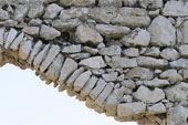 Adriatic area until the Roman occupation. These
were the Histrians, Liburnians and Japodes. The closest connections and
relations, mostly of a commercial but sometimes also of a warlike nature
(over pasture boundaries or access to water), were between the
Liburnians and the Japodes. In the last few centuries BC, the
Liburnians, who had their proto-urban bases and coastal harbours in
Osor, Krk, Rab, Omišalj and Bakar, gradually drove the Japodes out into
the hinterlands. In the hinterlands of Rijeka,
in the Vinodol region, in the surroundings of Senj and Jurjevo, a
Liburnian-Japodian cultural mixture was created. Connections with the
continental area were strengthened by expansion of the Celtic tribes
that took possession of the pre-Alpine regions, so the settlements on
the northern Adriatic coast and in the hinterland (Kastav, Grobnik,
Grižane) became important trading points between the Hellenic-Etruscan
civilisation and Central Europe. Adriatic area until the Roman occupation. These
were the Histrians, Liburnians and Japodes. The closest connections and
relations, mostly of a commercial but sometimes also of a warlike nature
(over pasture boundaries or access to water), were between the
Liburnians and the Japodes. In the last few centuries BC, the
Liburnians, who had their proto-urban bases and coastal harbours in
Osor, Krk, Rab, Omišalj and Bakar, gradually drove the Japodes out into
the hinterlands. In the hinterlands of Rijeka,
in the Vinodol region, in the surroundings of Senj and Jurjevo, a
Liburnian-Japodian cultural mixture was created. Connections with the
continental area were strengthened by expansion of the Celtic tribes
that took possession of the pre-Alpine regions, so the settlements on
the northern Adriatic coast and in the hinterland (Kastav, Grobnik,
Grižane) became important trading points between the Hellenic-Etruscan
civilisation and Central Europe. During the 2nd and 1st centuries BC, the Romans became the strongest power on the Adriatic and played a crucial role in the gradual process of Romanisation of the indigenous people. Epigraphic sources tell us that the 1st century BC marked a very intense process of colonisation of Italic immigrants, especially from the Po valley and the Veneto. Before formation of the Empire, Italic peoples used to hold important functions in the public life of the towns of Osor (Apsoros), Krk (Curicum), Beli (Caput Insulae) and Rijeka (Tarsatica). At that time, the Kvarner area formed the north-western part of the province of Dalmatia. Ancient urbanisation meant the construction of new facilities within indigenous settlements: the building of new squares, temples and baths; renovation of streets; construction of waterworks and sewage system channels; laying out of burial grounds. Entirely new settlements grew up on the land along important sea routes, like Tarsatika, Ad Turres (Crikvenica), Selce, or Fulfinum beneath today’ s town of Omišalj. In late antiquity, that is, in the 4th century, the roads between Italy and Dalmatia were renovated, as well as some of the routes that pass across the Croatian Littoral. A defence system for the region was organised to protect against barbarian invasions from the east. The centre of the new region became Tarsatika (today’ s old part of the town of Rijeka), where at the location of an early antique coastal trading town a mighty military camp with headquarters was built, and the bathes (thermae) were enlarged. After the Visigoth migrations in the 5th century, there began a period of gradual renewal that was marked by the rule of the Ostrogoth kingdom with its seat in Ravenna. It was a period in which dioceses were formed, and monumental Christian churches were built and adorned with marble furniture and floor mosaics were. After the end of the Gothic-Byzantine war, the renewed Empire led by Justinian built a series of fortresses and renovated the centres of Christianity. This short cultural and economic “renaissance” was interrupted by the first waves of the Avar-Slavic migrations that reached our region around 600 AD. After that came a period of turmoil, with fights for survival of the remaining urban centres on Kvarner’s islands, and also a period of complete ethnical changes in the hinterlands. At the end of the 8th and beginning of the 9th centuries, simultaneously with the establishment of political rule by Charlemagne, the coastal area – the Littoral – was permanently settled by the Croats who soon moved to the islands under Byzantine authority, especially the islands of Krk and Cres. The process of converting the Croats to Christianity on the islands, where diocesan centres were continuously active, was finished in the 9th and 10th centuries. Christianisation of the coastal region, particularly in the Vinodol area, was slower – the Croats there maintained their military and clan system until the flourishing of feudalism at the beginning of the 12th century and the formation of the Croatian-Hungarian Kingdom. Gradina (hill fort) is the name given to the prehistoric settlements surrounded by dry-stone walls and located on elevations that could be defended more easily or hilltops commanding good views of the surrounding area and enabling visual communication between individual settlements. Depending on the size and appearance of the settlement and specific features of the local dialect, several variants of the word Gradina are found, such as Gradac, Grac, or Gračišće. On the island of Krk, where the local variant of a retoromanian dialect was in use until the 19th century, these locations have names of Roman origin, such as Kaslir, Kostrij or Kastril. The word Gradina also indicates the ruins of medieval castles, as in Gradina Drivenik, Gradina Grižane, Gradina Ledenice or Gradina Trsat. 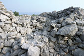 Gomila (heap, pile) is a term often used in archaeology to describe
a circular mound of stones or earth that can result either from the
centuries-long clearing of karst ground and piling up of stones along
the borders of plots, in which case it is called a gromača, or by the
building up of conical piles that can be several metres high. The term
often refers to tumuli (burial mounds) that can be several metres in
diameter and that hide graves from the Copper Age or, more likely, the
Bronze Age, but rarely from the Iron Age. They are often found in
dominant positions and hilltops, on infertile karst pastures and
wind-exposed plateaus, or on elevations above arable karst fields. Gomila (heap, pile) is a term often used in archaeology to describe
a circular mound of stones or earth that can result either from the
centuries-long clearing of karst ground and piling up of stones along
the borders of plots, in which case it is called a gromača, or by the
building up of conical piles that can be several metres high. The term
often refers to tumuli (burial mounds) that can be several metres in
diameter and that hide graves from the Copper Age or, more likely, the
Bronze Age, but rarely from the Iron Age. They are often found in
dominant positions and hilltops, on infertile karst pastures and
wind-exposed plateaus, or on elevations above arable karst fields.Hum is a term that refers to a top of a hill or elevation that often hides an archaeological site from the prehistoric or early medieval period. There are several variants of this term that also indicate places that hide archaeological sites beneath them, such as Humac, Hlam, Helm, Halm, or Halmac. Grobišće is a term used in the northern Croatian Littoral area to describe an abandoned plot of land or a barren area that used to be a cemetery. One location of a grobišće is near to the town of Grobnik, with traces of a burial ground from the Iron Age, early Antiquity and early Middle Ages. Old Croatian and early medieval cemeteries across the Vinodol valley often bear that name. Mirine is a name of Roman origin (with variants Merine, Merišća or Mire) that refers to the ruins or ruined walls of buildings, mostly from the Antiquity or late Antiquity. 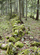 The
Liburnian Limes is a system of defensive walls, observation posts
and towers, actually a group of defensive establishments built by the
late Roman state to protect the eastern border of Italy from barbarian
invasions. The Roman Empire built that system of fortifications and
barriers on communication routes in our region during the 4th century.
The central military camp with headquarters was located in the coastal
settlement of Tarsatica (the old town of today’s Rijeka) from where the
wall (limes) with regularly distributed observation posts and towers
stretched over Kozala and Veli Vrh towards Donje Jelenje. Another wall
was built on the karstic hilltops above Obruč (the upper flow of the
River Rječina), from where it wound through the hinterland of Studena
and up into the mountainous hinterlands towards Željezna vrata. The
branch of the limes that closes the hollow between Prezid i Babno polje
even today demarcates the border between Slovenia and Croatia. The limes
is spatially the largest, but unfortunately not easily approachable,
building monument from the period of Late Antiquity in the Kvarner
region. Some of its shorter sections have been preserved and are
accessible in the areas of Rijeka (Kalvarija), Studena (Za Presikom and
Vranjeno) and Prezid. The
Liburnian Limes is a system of defensive walls, observation posts
and towers, actually a group of defensive establishments built by the
late Roman state to protect the eastern border of Italy from barbarian
invasions. The Roman Empire built that system of fortifications and
barriers on communication routes in our region during the 4th century.
The central military camp with headquarters was located in the coastal
settlement of Tarsatica (the old town of today’s Rijeka) from where the
wall (limes) with regularly distributed observation posts and towers
stretched over Kozala and Veli Vrh towards Donje Jelenje. Another wall
was built on the karstic hilltops above Obruč (the upper flow of the
River Rječina), from where it wound through the hinterland of Studena
and up into the mountainous hinterlands towards Željezna vrata. The
branch of the limes that closes the hollow between Prezid i Babno polje
even today demarcates the border between Slovenia and Croatia. The limes
is spatially the largest, but unfortunately not easily approachable,
building monument from the period of Late Antiquity in the Kvarner
region. Some of its shorter sections have been preserved and are
accessible in the areas of Rijeka (Kalvarija), Studena (Za Presikom and
Vranjeno) and Prezid.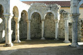 The
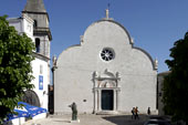
Early Christian Basilica follows the architectural pattern of the
basilica as a public building from Roman urban architecture. In the 5th
and especially 6th centuries, several monumental churches were built in
the Kvarner area following the example of basilicas built by oriental
architects in the dioceses of Milan and Aquileia. The experience gained
from building these churches and their architectural models was then
used on Kvarner, though adopting some specific local features. A
basilica is essentially an elongated rectangular, three-aisled building
with a nave supported by columns and raised above the side aisles. In
contrast to early Romanesque churches, basilicas are flooded with light.
They can either have a flat back wall with apses inside (like the church
of St. Nicholas in Mire The
Early Christian Basilica follows the architectural pattern of the
basilica as a public building from Roman urban architecture. In the 5th
and especially 6th centuries, several monumental churches were built in
the Kvarner area following the example of basilicas built by oriental
architects in the dioceses of Milan and Aquileia. The experience gained
from building these churches and their architectural models was then
used on Kvarner, though adopting some specific local features. A
basilica is essentially an elongated rectangular, three-aisled building
with a nave supported by columns and raised above the side aisles. In
contrast to early Romanesque churches, basilicas are flooded with light.
They can either have a flat back wall with apses inside (like the church
of St. Nicholas in Mire
 near
Baška), or a semi-circular apse (St. John’s in Rab, St. Mary’s in Osor).
In the 5th century, basilicas with a cruciform plan were built, like the
basilica in Mirine near Omišalj, or the basilica beneath St. Mark’s in
Baška. Pseudo-basilicas are single-aisled churches with an apse and
transept that have auxiliary rooms along their sidewalls, or are part of
a monastery (like the church of St. Martin on Cres, the church in
Cickini above Malinska, the church of St. Peter in Kanajt near Punat, or
the church of St. Lucy in Jurandvor). near
Baška), or a semi-circular apse (St. John’s in Rab, St. Mary’s in Osor).
In the 5th century, basilicas with a cruciform plan were built, like the
basilica in Mirine near Omišalj, or the basilica beneath St. Mark’s in
Baška. Pseudo-basilicas are single-aisled churches with an apse and
transept that have auxiliary rooms along their sidewalls, or are part of
a monastery (like the church of St. Martin on Cres, the church in
Cickini above Malinska, the church of St. Peter in Kanajt near Punat, or
the church of St. Lucy in Jurandvor). Buried Greek treasure is a motif of various local legends that often point to some important archaeological sites. Legends about treasures buried in the earth, put into a pot or sewn up in a goat’s or calf’s belly are widespread on Kvarner. Sometimes the treasure is buried in a cave or beneath some large stone (on the slopes of Mount Učka) and guarded by a mythical creature called a vila or malik. On the islands and along the coastline, the indigenous people whom the Croats encountered at the time of settlement in the area of the Byzantine Empire were usually referred to as “the Greeks”. Some of these ancient people fled from their settlements, leaving numerous ruins behind, built mostly during the Roman era, that would fire the imagination of Croatian newcomers. Over the later centuries of the High Middle Ages, the Croatian people used to sail across the Mediterranean sea and get acquainted with modern Greeks, which resulted in adding new elements to ancient legends, like the stories of Greek sailors from Patras who would return to these locations with some ancient maps, in search of treasure to take back home. 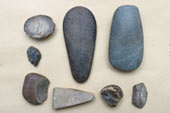 Polished
stone axes and wedges were made of hard volcanic rock that cannot be
found on calcareous rocks in our region. These tools, used in the New
Stone Age and Bronze Age, came through trading with far away places and
served as money. A great part of the stone axes and blades from the
Kvarner area (especially on the island of Krk) were found in old stone
or shepherd’s houses. According to Old Slavic beliefs that were
preserved in local customs up to recent times, in order to protect a
house from thunder or fire, a flint or axe made from volcanic rock was
to be inserted into a doorstep, doorpost or lintel. In the Čakavian
dialect, the name for a stone axe was strila or šajeta, which explains
the connection between sparks caused by rubbing these stones on the one
hand, and thunder and lightning on the other, which are attributes of
the Old Croatian divinity Perun, the god of thunder. Polished
stone axes and wedges were made of hard volcanic rock that cannot be
found on calcareous rocks in our region. These tools, used in the New
Stone Age and Bronze Age, came through trading with far away places and
served as money. A great part of the stone axes and blades from the
Kvarner area (especially on the island of Krk) were found in old stone
or shepherd’s houses. According to Old Slavic beliefs that were
preserved in local customs up to recent times, in order to protect a
house from thunder or fire, a flint or axe made from volcanic rock was
to be inserted into a doorstep, doorpost or lintel. In the Čakavian
dialect, the name for a stone axe was strila or šajeta, which explains
the connection between sparks caused by rubbing these stones on the one
hand, and thunder and lightning on the other, which are attributes of
the Old Croatian divinity Perun, the god of thunder. Early Byzantine fortifications were built as early as the middle of the 6th century AD, when Kvarner was under the tough rule of the skilful Byzantine emperor Justinian. After the wars against the former rulers of the coastal area, the Ostrogoths, Justinian created a mighty fleet that ruled the Adriatic. The insecure sea routes among the islands and coves were secured by the construction of several checkpoints, observatory posts, towers and large and fortifications. Around these fortifications civil settlements had developed and churches were renovated or built. In the Bay of Rijeka, in the strait between the mainland and the island of Krk, on the small island of Sveti Marko (St. Mark) are the ruins of the Almis fortification that was constructed in that period. Along the eastern coast of the island of Krk are traces too of fortifications at the locations of Zidine near Šilo, Veli grad on Cape Glavina, and the large fortification of Korintija (Corinthia) above the civil settlement in Mala luka. This row of fortifications is continued on the island of Rab with the fortresses of Kaštelina and Sveti Kuzma. In the early Byzantine period, the fortifications in the old towns of Krk and Osor were renovated, and an impressive fortification was built on the small island of Palacol, south of the island of Lošinj. The Liburnian people ruled the Kvarner area at the beginning of the last millennium BC. During Roman occupation, the Liburnians dwelled along the narrow stretch of coastal land between the River Raša in eastern Istria and the River Krka in Dalmatia and on all the Kvarner islands. The Liburnians were the first historically known population in this area, mentioned by Greek writers as early as 734 BC. But due to pressure from Greek colonists during the last centuries BC, the Liburnians migrated to the part of the coast that was formerly ruled by the Japodes, which resulted in an interesting mixed culture. The Liburnians were trade and seafaring people who established trade connections in the hinterlands of Rijeka with tribes from the pre-Alpine regions in the last centuries BC. The Liburnian cipus is a specific form of gravestone that was used to mark the graves of indigenous Liburnian people in the area that was already romanised in the first century AD. Cipuses are phallic in shape, mostly cylindrical, sometimes conical, with a rounded top that is sometimes chiselled as a pine cone. In the Kvarner area, Cipuses were found on the island of Krk and Rab. The house of Kurikti ruled the central part of the island of Krk. Its administrative centre was today’s town of Krk, founded three thousand years ago as a coastal settlement surrounded by a defensive dry-stone wall. During the civil war between the armies of Gnaeus Pompeius and Julius Caesar, partly waged in 49 BC in the waters off Krk, the people of Krk, at that time Caesar’s allies, rebuilt the ancient town walls. Some parts of these have remained preserved until today. Under Roman rule, the town of Krk was known as Curicum, but in the early Middle Ages this name referred to the whole island that had also been inhabited in prehistoric times by the Fertinats in the north, with the administrative centre in Fulfinum. The town of Krk was later known as Vecla, which means The Old Town. This is the reason why local people even today call it Veja. The Amber Route passed through the area of Kvarner because it is, beside the Bay of Trieste, the place where the Mediterranean Sea reaches most deeply into the European continent. This simple geographical fact has been the basis of all prehistoric (and modern as well) routes between the Baltic, Central Europe and pre-Alpine areas, whereas the Adriatic Sea was used as the maritime route to the great civilisations of the south-east Mediterranean. Amber, a seemingly plain yellow-brown resin known as elektron in Greek that was dug out of peat bogs on the coast of the cold Baltic Sea, was highly prized by the people who lived along the Adriatic coasts and in the Apennines in the last millennium BC, and even during the Roman domination. People who lived along the mentioned transalpine routes owed their civilisational progress to the amber and salt trade. Untreated amber was transported to the workshops of Etruscan master craftsmen who would work it into jewellery and then returned to Central Europe with other pieces of jewellery and ornamentation. The ancient inhabitants of the Kvarner area - the Liburnians and the Japodes - would take part in this trade in amber that continued for many centuries (although it was interrupted for a while due to Celtic expansion). This is why the Kvarner islands were called the Elektrides (Amber islands) by Hellenic writers. However, items made of amber have been found not only in graves near Krk and Osor, but also in prehistoric settlements in the hinterland of Rijeka - Kastav and Grobnik. The value of amber came from the belief that it had healing and protective powers. The first mention of oak barrels on Kvarner had to do with the months-long maritime blockade of the island of Krk in the year 49 BC, in which the armies of Pompeii and Caesar took part. With their food running out, Caesar’s forces had no choice but to break through the blockade and escape to the mainland. From the historic point of view, the battle that took place in the strait between Jadranovo, Cape Bejavac and the small island of Sveti Marko is interesting because, among other reasons, this was the first time that wooden vessels - wine barrels - were mentioned. Caesar’s soldiers, mostly non-swimmers (recruited from the north Italic people, the Opitergini), made improvised rafts of barrel staves because they had no other wood at their disposal. This proves that the inhabitants of Kvarner were at that time already familiar with oak barrels as a means of transporting and storing wine, and not only with the more usual form of ancient storage - ceramic amphoras. 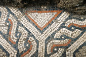 Tarsatica
is an ancient settlement whose traces can still be found in the old town
of Rijeka. The settlement had its roots on a hill above Pulac, which has
prehistoric remains of Gradišće. In the last few centuries BC, the
settlement stretched down to a hill near the sea (between today’s
Ciottina and Pomerio Streets). Under Roman rule, the indigenous
Liburnian community received Italic migrants, the settlement became a
municipium and stretched south-east towards the mouth of the River
Rječina (the Liburnians called it Tarsa). Along the main street (today’s
Užarska Street), public buildings and housing were constructed.
Monumental buildings were also erected around the monastery church of
St. Jerome and the church of St. Mary. Tarsatica
is an ancient settlement whose traces can still be found in the old town
of Rijeka. The settlement had its roots on a hill above Pulac, which has
prehistoric remains of Gradišće. In the last few centuries BC, the
settlement stretched down to a hill near the sea (between today’s
Ciottina and Pomerio Streets). Under Roman rule, the indigenous
Liburnian community received Italic migrants, the settlement became a
municipium and stretched south-east towards the mouth of the River
Rječina (the Liburnians called it Tarsa). Along the main street (today’s
Užarska Street), public buildings and housing were constructed.
Monumental buildings were also erected around the monastery church of
St. Jerome and the church of St. Mary. Burial grounds were laid out along the access roads, one near today’s Ciottina Street, in the area between Rijeka skyscraper (Riječki neboder), the Capuchin monastery and Brajda, and the other one on the eastern part of the town, near today’s Strossmayerova Street. In the second half of the 4th century, the coastal settlement was widened and protected by a mighty new system of defensive double walls with towers. Tarsatika became an important military fortification for the crew that built and worked on the system of defensive walls and fortification - the limes, at that time called the Claustra Alpium Iuliarium (Alpine enclosure). The town baths (thermae) were also enlarged, above which after the victory of Christianity a monumental complex of early Christian sacred buildings with fine floor mosaics was built by the 6th century. The medieval church was built upon the ruins of an early Christian basilica. On the town’s western access road, near today’s Barčićeva Street, was the graveyard church of St. Andrew (crkva sv. Andrije) decorated with floor mosaics. The church of St. Lawrence (crkva sv. Lovre) in Sušak could also be of early Christian origin. The town suffered several earthquakes and migrations: It was last mentioned as a small coastal settlement in 799 when its inhabitants killed the Friulian army leader, margrave Eric, in an ambush on the road near the church of St. Lawrence. The following year Tarsatika was burned down in a raid of revenge, and the surviving inhabitants moved to a more protected hill where they established a new settlement called Trsat. Volcera (pronounced Bolkera) is the old, pre-Roman name for the settlement that gave its name to the ancient town of Bakar, located at the top of Bakar Bay. Recent archaeological excavations have confirmed that the settlement was founded in pre-Roman times, as early as the second millennium BC. The Liburnian settlement was built on a small stony hill above the sea, in the location of today’ s upper town (Gornji grad), with a church and castle. With gradual Romanisation, the settlement stretched downhill to the sea. As the ancient era and early Byzantine period drew to a close, the hill once again became the centre of a new medieval settlement that was built within the perimeters of the prehistoric hill fort. In the 11th century, the Arabic travel writer Edrisi called it Bkri, which was the origin of the Italian name Buccari and the Croatian name Bakar. Ad Turres was an ancient station located halfway between Rijeka and Senj, at the mouth of the stream of Dubračina. Its traces can still be found underneath the football stadium complex. In the 1st century AD, it was the location of the only brickyard on Kvarner that we know of today - the factory for producing bricks, ceramic dishes and amphoras, owned by Sext Metilio Maxim. In Late Antiquity, a small fortification was built on a cape south of the mouth of the stream of Dubračina (called Oeneus in ancient times). Later on, a church of St. Mary was erected on the ruins of that fort in the Middle Ages - hence the name of today’s Crikvenica (crkva or crikva means “church” in Croatian). At the beginning of the 15th century, the ruins of the fort came into the possession of Paulist monks who renovated the whole complex and turned it into a monastery. During the great migrations, descendants of the inhabitants of Turres (meaning tower, fortress) eventually moved to a hilltop location that was easier to defend - the medieval town of Kotor. 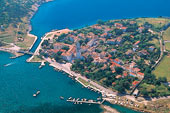 Apsorus
is the ancient name for the town of Osor, located on the south-west of
the island of Cres, on a narrow strip of land that used to connect the
islands of Cres and Lošinj before the channel between them was dug out.
Osor was an important Liburnian foothold, as we know from some valuable
discoveries made in burial grounds. Like Krk, Osor was also already
surrounded by defensive walls in the 2nd and 1st centuries BC. The name
Osor has to do with the legend of the hero Apsyrtus, Medea’s brother
from the Greek myth of the Argonauts. In ancient times, Osor was an
important harbour town and a maritime centre on the eastern Adriatic sea
route. In the 6th century it became the centre of the diocese, as we
have learned from the ruins of the early Christian basilica and
baptistery beneath the floor the church of St. Mary. Apsorus
is the ancient name for the town of Osor, located on the south-west of
the island of Cres, on a narrow strip of land that used to connect the
islands of Cres and Lošinj before the channel between them was dug out.
Osor was an important Liburnian foothold, as we know from some valuable
discoveries made in burial grounds. Like Krk, Osor was also already
surrounded by defensive walls in the 2nd and 1st centuries BC. The name
Osor has to do with the legend of the hero Apsyrtus, Medea’s brother
from the Greek myth of the Argonauts. In ancient times, Osor was an
important harbour town and a maritime centre on the eastern Adriatic sea
route. In the 6th century it became the centre of the diocese, as we
have learned from the ruins of the early Christian basilica and
baptistery beneath the floor the church of St. Mary. 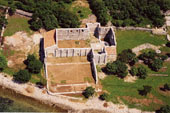 Fulfinum
was a Roman city whose ruins are now located south-west of Omišalj on
the island of Krk, close to the cove of Sepen. Fulfinum originated from
a spacious Liburnian hill fort overlooking the Bay of Omišalj, where the
town of Omišalj was later built. In the first half of the 1st century,
Roman colonists, mostly veteran soldiers, built a new town not far from
the old settlement and the sheltered cove. It had streets laid out in
regular grid form, all the necessary public buildings and waterworks
that were renewed under the emperor Domitian. In the 5th century, a
grand Early Christian basilica, locally known as the Mirine, was
erected near the burial ground on the western border of the city. At the
beginning of the Middle Ages, Croatian incomers founded their own
settlement (Omišalj) on the more secure and healthier location of the
old Liburnian hill fort, and the Mirine church became part of the
Benedictine monastery. Fulfinum
was a Roman city whose ruins are now located south-west of Omišalj on
the island of Krk, close to the cove of Sepen. Fulfinum originated from
a spacious Liburnian hill fort overlooking the Bay of Omišalj, where the
town of Omišalj was later built. In the first half of the 1st century,
Roman colonists, mostly veteran soldiers, built a new town not far from
the old settlement and the sheltered cove. It had streets laid out in
regular grid form, all the necessary public buildings and waterworks
that were renewed under the emperor Domitian. In the 5th century, a
grand Early Christian basilica, locally known as the Mirine, was
erected near the burial ground on the western border of the city. At the
beginning of the Middle Ages, Croatian incomers founded their own
settlement (Omišalj) on the more secure and healthier location of the
old Liburnian hill fort, and the Mirine church became part of the
Benedictine monastery.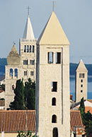 Arba, the town of Rab, is the urban centre of the island of Rab. The town was gradually built on Liburnian foundations in the 2nd and 1st centuries BC, with the streets laid out in a regular grid form, defensive walls and public buildings. Under the rule of the first emperor, Octavius Augustus, Rab was known as Felix Arba (Happy Rab). In Late Antiquity it became the centre of the diocese. Particularly impressive is the monumental church of St. John (crkva sv. Ivana) that was built during that period. |
|
|
|
|||||
|
THE KVARNER COUNTY TOURISM OFFICE 51410 Opatija, Nikole Tesle 2, Tel: +385/51/272-988, Fax: +385/51/272-909 http://www.kvarner.hr, E-mail:kvarner@kvarner.hr |
|||||