
THE ISLAND OF CRES
Cres, Osor, Punta Križa, Valun,
Orlec, Beli, Dragozetići, Belej,
Lubenice, Martinšćica
With its wealth and number of plant species and endems, amphibians and unpoisonous reptiles, ornithologial reserves, monuments of nature, protected landscapes or those nominated to become such, hydroarcheological localities, rural and historical units, buildings and complexes, the island of Cres is an extraordinary ecological and cultural Kvarner treasure that is unlikely to leave any visitor indifferent.
The harmonic interrelation of man and nature, creativity and strength discovered as far back as the earliest prehistoric times, have developed through the centuries. Today, they are felt more strongly here than anywhere else. The same and special areas of the island impress with their harmony and peace, inspiring respect and the need for preservation. With its elongated shape, 66 km long, extending from cape Jablanac to the Suha punta cape, the island of Cres represents the mainstay of the Kvarner Bay. It is divided from the mainland by Vela vrata and the Rijeka Bay, from the island of Krk by the Srednja vrata and Kvarnerić, from the island of Lošinj by a dug-out, eleven metre wide channel (Kavanada, Cavanella). For a long time, it was recorded as the second largest Adriatic island. However, recent measurements have shown that the size of the island of Cres is identical to that of Krk (405.78 km2).
There are three separate wholes on the island of Cres. The northern, highest part of the island is characterized by deciduous wood and underbrush of the community of the oak Quercus pubesscens, hop hornbeam (Ostrya cerpiublia), oriental hornbeam (Carpinus orientalis) and holly oak (Quercis ilex). The central part has been transformed into pasture grounds, olive-groves and vineyards, while the western, lower part, is an area covered by dense evergreen Mediterranean woods.
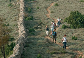
The island tracks intersect all three wholes, and follow either the traces of shepherds’, labourers’ footprints and trails or go in search of paths of prayer and spirituality.
THE TRAMUNTANA PATHS
 In
the northern, highest part of the island is located the area called
Tramuntana, covering a surface area of 81.25 km. An area of powerful
natural, historical and ethnological heritage will meet the eyes of
a curious hiker. Karst phenomena follow one after another
(sink-holes, bays, gulleys, cave pits) natural woods (various oak
and hornbeam species), freshwater ponds - small ecosystems
(Kosamčev, Paiska, Palvanja, Peć...), as well as signs and
testimonies of past times (tumuli, forts, Roman bridges, roads...),
way of life (popular architecture, drywalls, ravines...), culture
and spirituality (small churches, votive monuments), legends and
beliefs (the elf «macmalić», witches and wizards).
In
the northern, highest part of the island is located the area called
Tramuntana, covering a surface area of 81.25 km. An area of powerful
natural, historical and ethnological heritage will meet the eyes of
a curious hiker. Karst phenomena follow one after another
(sink-holes, bays, gulleys, cave pits) natural woods (various oak
and hornbeam species), freshwater ponds - small ecosystems
(Kosamčev, Paiska, Palvanja, Peć...), as well as signs and
testimonies of past times (tumuli, forts, Roman bridges, roads...),
way of life (popular architecture, drywalls, ravines...), culture
and spirituality (small churches, votive monuments), legends and
beliefs (the elf «macmalić», witches and wizards).
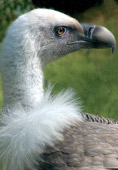
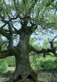
The centre of Tramuntana is the town of Beli, “a prehistoric fort that has been living uninterruptedly for 4000 years now”. Today, one can find the headquarters of the ecological centre Caput Insulae Beli, established in order to protect the griffon vultures (Gyps fulvus or «orli» in dialect) as well as for the preservation of the overall natural and cultural-historical environment. Today, in terms of protection categories, the recording of Tramuntana in the list of protected natural areas has been proposed. In the village of St. Peter, there is a protected monument of nature, a huge, secular oak tree, and of the two special ornithological Cres reserves, Kruna i Pod Okladi, the first one is located in the area of Tramuntana.
Today, more than 70 nesting couples of griffon vultures live in both reserves. Any kind of upsetting of the vultures or disturbing of their habits is punishable with high fines.
Tramuntana offers all its peculiarities through three marked, circular paths (Stoza Tramuntantana I, II and III), all starting and ending in Beli.
Organized birdwatching.
Along the path it is forbidden to pick flowers, autochtonous plants
and wild fruit. The disturbing of sheep and all other animals is
also forbidden. If you have a dog with you, it must be kept on a
leash at all times. Do not deviate from the path.
|
|
Time required
for a slow-pace walk: - Stoza Tramuntana I Two hours - Stoza Tramuntana II One hour and 30 minutes - Stoza Tramuntana III One hour and 40 minutes |
|
|
You should procure the guidebook for the instructive path “Stoza Tramuntana I” |
|
|
Eko
centar Caput Insulae Beli
Town of Cres Tourism Office |
CLIMB ON SIS AND GORICA
 The
climb to the highest peak in Cres, Gorica (648m), is relatively
easy. The starting point is from the saddle Križići (371m), the
crossroads for Beli, the narrowest part of the island of Cres (2km),
marked by an iron cross, wherefrom an exceptional view extends on
both sides of the island of Cres. The path follows the mountain
ridge along the drywall and rocky ground, a real «herb pharmacy» of
sage(Salvia offinalis), first of all. Before Gorica, you reach the
much more famous peak of Sis (639m), with the remnants of a
prehistoric fort. This is the greatest observation point in the
whole of the Kvarner Gulf.
The
climb to the highest peak in Cres, Gorica (648m), is relatively
easy. The starting point is from the saddle Križići (371m), the
crossroads for Beli, the narrowest part of the island of Cres (2km),
marked by an iron cross, wherefrom an exceptional view extends on
both sides of the island of Cres. The path follows the mountain
ridge along the drywall and rocky ground, a real «herb pharmacy» of
sage(Salvia offinalis), first of all. Before Gorica, you reach the
much more famous peak of Sis (639m), with the remnants of a
prehistoric fort. This is the greatest observation point in the
whole of the Kvarner Gulf.
![]() Required
time:
Required
time:
- Križići - Sis 45 minutes
- Križići - Gorica one hour 15 minutes
CRES ISOLATED SMALL CHURCHES
Some sixty small churches are scattered along the island,
outside major village and town centres. As to architecture,
they belong to Gothic and Romanic styles and they all face
the same direction: apses to the northeast, and entrance to
the southwest. In some eighteen churches, pilgrimages are
organized and Holy Masses are held even today, on the
occasion of the celebration of their patron saints. In the
northern part of the island, Tramuntana, there are ten
churches. In the central part, in the areas of the towns of
Cres and Lubenice there are three churches and in the area
of Orlec – Martinščica 11. In the southern part of the
island of Cres, on the route from Belej - Osor, there are 18
churches and pilgrimages are organized in three of them. Do
not forget to wear suitable walking shoes and take
sufficient supplies of water along!
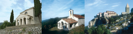
PATHS IN THE SURROUNDINGS OF THE TOWN OF CRES
From the centre of the Town of Cres, the old town of which has been occupied by Gothic and Rennaissance churches and palaces, there are several paths and one seaside promenade:
Lungomare St. Mikule
The starting point is from the central Square, Trg Frane Petrića, through the quay - Palada towards the Church of St. Mikula and then, further on along the seaside, below Hotel Kimen to the cape of the Cres Bay, to the Kovačine motorcamp.
![]() Time
required: 30 minutes
Time
required: 30 minutes
Path Cres - St. Salvador - St. Blaž
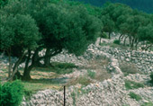
The path, 10 km long, departs on the northern part of the town through secular olive groves and along the dry walls up to the sanctuary of St. Salvador (expanded in 1857). It then follows to the pebble beach and the church of St. Blaž.
![]() Time
required:
Time
required:
- Cres - Sv. Salvadur one hour
- Cres - Sv. Blaž three hours
Cres - Loznati - Lovreški
The starting point of the path is near the Franciscan monastery, the path then climbs for 7.5 km along olive groves and pasture grounds to the village of Loznati and the locality of Lovreški, where the remnants of the church dedicated to St. Lovro Mučeniku (6th century) may be visited.
![]() Time
required:
Time
required:
Cres - Loznati two hours
Loznati - Lovreški one hour
Cres - Krčina
From the Cres marina, Piskel Bay, a path 6.5 km long leads via the
Napoleon path to the settlement of Krčina. The village was established
(and hence got the name: krčiti, clear the land) by land-clearing of the
wood of holly oak, in order to obtain agruicultural land.
![]()
![]() Time
required:
Time
required:
one hour and 30 minutes
Cres - Nedomisje
To the right of the Piskel Bay, following the path of the water
supply system, along olive groves and rocky ground, a path leads to the
fishing village of Valun.
![]() Time
required:
Time
required:
one hour and 30 minutes
HIBERNICIA
Hiking-educative path leading through the marvellous areas of the
Lubenice region.
|
|
Town of Cres
Tourst Office phone 051/571 535 www.tzg-cres.hr tzg-cresa@ri.t-com.hr We recommend that you wear strong shoes and bring enough water along! |
