
THE ISLAND OF RAB
Rab, Lopar, Kampor, Supetarska Draga,
Barbat,
Banjol, Mundanije, Palit
 The
island of Rab offers two faces to its visitors. The northeastern
one, towards the Velebit massif, bare, steep, with vertical slopes,
and the southwestern, towards the island of Cres and Lošinj, marked
by gentle valleys and luxuriant vegetation. The first one is almost
inaccessible, the second more than suitable for recreation and
walking. The island has a surface area of 93,6 km2. Along the
longest line, from cape Glavina to cape Sorinj, there are 22 km, and
in the widest point, from cape Šilo to cape Kristofor, 10 km. The
favourable climatic conditions of Rab are well known. Mild winters
and moderately warm summers, the great number of sunny hours (2479
per year) and of sunny days (91 per year) are only some of the
peculiarities of Rab. The island owes these conditions to the
Kamenjak mountain range, that protects it from the cold and strong
winds coming from Velebit. There are other peculiarities, besides
the climatic ones. With more than 300 water sources, areas of
luxuriant vegetation are valued as protected areas and reserves.
The
island of Rab offers two faces to its visitors. The northeastern
one, towards the Velebit massif, bare, steep, with vertical slopes,
and the southwestern, towards the island of Cres and Lošinj, marked
by gentle valleys and luxuriant vegetation. The first one is almost
inaccessible, the second more than suitable for recreation and
walking. The island has a surface area of 93,6 km2. Along the
longest line, from cape Glavina to cape Sorinj, there are 22 km, and
in the widest point, from cape Šilo to cape Kristofor, 10 km. The
favourable climatic conditions of Rab are well known. Mild winters
and moderately warm summers, the great number of sunny hours (2479
per year) and of sunny days (91 per year) are only some of the
peculiarities of Rab. The island owes these conditions to the
Kamenjak mountain range, that protects it from the cold and strong
winds coming from Velebit. There are other peculiarities, besides
the climatic ones. With more than 300 water sources, areas of
luxuriant vegetation are valued as protected areas and reserves.
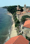
TOWN PARK KOMRČAR AND THE PROMENADE
BELOW THE PARK
The luxuriant wood of the town of Rab, behind the Varoš, extends on
an area of 10 ha. Its story was written out, at the end of the 19th
century, by the Head forester Pravdoje Belia, Slovene, that despite
the numerous misfortunes afforested the area, taking care of his
first seedlings. Today, this park falls under the category of wood
park, with benches as resting places along the tracks crossing the
park. The park mostly consists of Aleppo, maritime, black pines,
holly oaks and laurel. The park reaches the Bay of St. Eufemija
accompanied by the famous promenade that extends under the park. It
is more than one kilometre long, situated on the sunny side and
completely sheltered from the wind. Covered by the crowns of pines,
agavas, cactuses and cypresses, in the immediate vicinity of the sea
and the sea rocks, it offers really extraordinary sensations.
We point out: In May the Istrian
bluebell (Campanula istriaca) blossoms on the Rab walls! Habitat of
a rare species of ferns, the Asplenium hybridum.
PENINSULA KALIFRONT AND WOOD DUNDO
 The
biggest wood complex is situated on the Kalifront peninsula and its
special part is the wood Dundo or Dundovo, proclaimed a special
reserve of wood vegetation as early as 1949. This is a real
Mediterranean holly oak (Quercus ilex) wood. In the course of
history, and particularly during World War II, many trees were
destroyed, so that today this wood is a stump wood. Namely, almost
all the existing trees have grown out of stumps of what once used to
be a real wood. Among holly oaks here are also laurel trees (Laurus
nobilis), trees of Aleppo (Pinus halepensis), maritime (Pinus
pinaster) and black pine (Pinus nigra). The peninsula Kalifront is
crossed by hiking tracks. The point of departure is on the road for
Suha punta. The tracks lead through the spacious wood area, but also
to many picturesque peeble bays (Kristofor, Ifnata, Planka, Sv.
Mara...). There are also two forester’s houses, in the wood Dundo
and in front of St. Mary’s Bay. Next to the first house, at half an
hour’s walk from the road to Suha punta, the oldest specimens of
holly oak, the so-called sjemenjaci can be seen, while the other
house offers a nice view of the sea. From Kalifront, it is also
possible to reach on foot St. Eufemija’s monastery and the memorial
graveyard in Kampor.
The
biggest wood complex is situated on the Kalifront peninsula and its
special part is the wood Dundo or Dundovo, proclaimed a special
reserve of wood vegetation as early as 1949. This is a real
Mediterranean holly oak (Quercus ilex) wood. In the course of
history, and particularly during World War II, many trees were
destroyed, so that today this wood is a stump wood. Namely, almost
all the existing trees have grown out of stumps of what once used to
be a real wood. Among holly oaks here are also laurel trees (Laurus
nobilis), trees of Aleppo (Pinus halepensis), maritime (Pinus
pinaster) and black pine (Pinus nigra). The peninsula Kalifront is
crossed by hiking tracks. The point of departure is on the road for
Suha punta. The tracks lead through the spacious wood area, but also
to many picturesque peeble bays (Kristofor, Ifnata, Planka, Sv.
Mara...). There are also two forester’s houses, in the wood Dundo
and in front of St. Mary’s Bay. Next to the first house, at half an
hour’s walk from the road to Suha punta, the oldest specimens of
holly oak, the so-called sjemenjaci can be seen, while the other
house offers a nice view of the sea. From Kalifront, it is also
possible to reach on foot St. Eufemija’s monastery and the memorial
graveyard in Kampor.
|
|
Expected
duration (slow-pace walk): - from the house Dundo to Kristofor Bay 40 minutes - from the house Dundo to St. Mara’s Bay one hour - from the house Dundo to Kampor one hour and 30 minutes |
Average physical fitness required
KAMENJAK PEAK
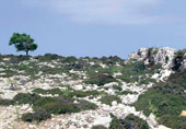 The
ascent to the Kamenjak mountain offers one of the most beautiful Rab
adventures. The mountain track was built (1932) based on the project
by the famous Ante Premu ić, who built the Premužić track on
Velebit. The best point of departure towards the highest peak on the
island of Rab, the elevation called Stra a (408 m), is the village
Mundanije or the Town of Rab. The marked point of departure is
located at the Rab bus station or in Mundanije, not far from the
Church of St. Matej. Autochtonous medicinal herbs and spices,
spurges, immortelle, cyclamen are part of the rich plant life that
we notice on our way. The peak offers one of the most beautiful
Kvarner sights – the Velebit massif some fifteen kilometres away,
Goli otok and other Kvarner islands.
The
ascent to the Kamenjak mountain offers one of the most beautiful Rab
adventures. The mountain track was built (1932) based on the project
by the famous Ante Premu ić, who built the Premužić track on
Velebit. The best point of departure towards the highest peak on the
island of Rab, the elevation called Stra a (408 m), is the village
Mundanije or the Town of Rab. The marked point of departure is
located at the Rab bus station or in Mundanije, not far from the
Church of St. Matej. Autochtonous medicinal herbs and spices,
spurges, immortelle, cyclamen are part of the rich plant life that
we notice on our way. The peak offers one of the most beautiful
Kvarner sights – the Velebit massif some fifteen kilometres away,
Goli otok and other Kvarner islands.
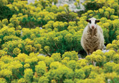
Reasonably good physical condition is required. Strong shoes are indispensable. Take water along. It is recommended to set off when the weather is fresh, or early in the morning. It is obligatory to close the gates on the pasture grounds, because of the sheep that graze there.
![]() Slow-pace walk duration :
Slow-pace walk duration :
- from Rab to the top of Kamenjak one hour and 30 minutes
- from Mundanije to the top of Kamenjak one hour
THE LOPAR PENINSULA
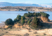 The
Lopar peninsula belongs to the protected landscape category. It
consists of a fertile valley and a hilly region, some 92 metres
high. There are a lot of small bays and capes connected by paths and
tracks. The Saramić Bay, Šilo cape, Šturić cape and bay, Zidine cape
with the prehistoric archeological site follow in a series. Two Bays
are particularly vast: Lopar and Crnika. The latter is famous for
the Paradise Beach, a spacious and shallow bay, one and a half
kilometres long. Do not forget to walk on this yellowish-reddish
sand, and also in the shallow sea extending for approximately one
hundred metres.
The
Lopar peninsula belongs to the protected landscape category. It
consists of a fertile valley and a hilly region, some 92 metres
high. There are a lot of small bays and capes connected by paths and
tracks. The Saramić Bay, Šilo cape, Šturić cape and bay, Zidine cape
with the prehistoric archeological site follow in a series. Two Bays
are particularly vast: Lopar and Crnika. The latter is famous for
the Paradise Beach, a spacious and shallow bay, one and a half
kilometres long. Do not forget to walk on this yellowish-reddish
sand, and also in the shallow sea extending for approximately one
hundred metres.
|
|
Town of Rab Tourism Office
Lopar Tourism Office |
