
THE ISLAND OF KRK
Baška, Dobrinj, Klimno, Krk,
Malinska, Njivice, Omišalj, Punat, Vrbnik
 The
famous centuries-old history of Krk has been recorded in the most
beautiful way through innumerable traces and paths as symbols of
stability and perseverance during the continuous changes and
challenges imposed by time. The island of Krk is a network of tracks
and paths pulled off time and finiteness. Unchanged through the
centuries, it leads through wood covered «drmuni» and bare pasture
grounds, fenced by dry walls, strewn by aromatic plants and sheep
droppings. The most recent track, with cleared paths along the
seaside, has been called a promenade. Krk shepherds and farmers have
imprinted in the soil the traces of their steadiness, endurance and
diligence, but also testimonies of the joy of living, life and
belief. These are kilometres long traces, passing along fertile
vineyards and olive-groves, near stone huts, graveyards and chapels.
They head towards quiet bays, fishing ports, towns and villages
celebrated in songs. The marks and signposts are part of the new
inventory, guiding those who are interested to an adventure rich in
diversity. The island of Krk, with the neighbouring island of Cres,
belongs to the category of the biggest Adriatic islands. Its size
stands out if the pertaining islands and ridges Prvić, Plavnik, Sv.
Marko, Zec, Galun, Košljun are added to the surface (405.78 km2):
The area of the island of Krk, 38 km long and 20 km wide is most
frequently
The
famous centuries-old history of Krk has been recorded in the most
beautiful way through innumerable traces and paths as symbols of
stability and perseverance during the continuous changes and
challenges imposed by time. The island of Krk is a network of tracks
and paths pulled off time and finiteness. Unchanged through the
centuries, it leads through wood covered «drmuni» and bare pasture
grounds, fenced by dry walls, strewn by aromatic plants and sheep
droppings. The most recent track, with cleared paths along the
seaside, has been called a promenade. Krk shepherds and farmers have
imprinted in the soil the traces of their steadiness, endurance and
diligence, but also testimonies of the joy of living, life and
belief. These are kilometres long traces, passing along fertile
vineyards and olive-groves, near stone huts, graveyards and chapels.
They head towards quiet bays, fishing ports, towns and villages
celebrated in songs. The marks and signposts are part of the new
inventory, guiding those who are interested to an adventure rich in
diversity. The island of Krk, with the neighbouring island of Cres,
belongs to the category of the biggest Adriatic islands. Its size
stands out if the pertaining islands and ridges Prvić, Plavnik, Sv.
Marko, Zec, Galun, Košljun are added to the surface (405.78 km2):
The area of the island of Krk, 38 km long and 20 km wide is most
frequently
 divided
into two units. The northern one, lower, covered by wood, more
inhabited and the southern one in the direction Vrbnik - Punat,
mostly bare, only partially covered with dense wood with the
spacious Bašćanska draga cut in.
divided
into two units. The northern one, lower, covered by wood, more
inhabited and the southern one in the direction Vrbnik - Punat,
mostly bare, only partially covered with dense wood with the
spacious Bašćanska draga cut in.
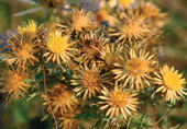
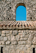
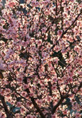
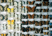
From the old times it has been called Zlatni otok (Insulae Aurea – golden island), due to the fertile vineyards and olive groves, the great number of hours of sunshine (2500 per year) and other characteristics, including the 1500 plant spacies, numerous Kvarner-Liburnian endems, 30 autochtonous species of anphibians and reptiles, more than 1450 butterfly species, special reserves : the ornithological one (Prvi, Glavina, Mala luka), wood vegetation reserve (Glavotok), park wood (Košljun). There are another 16 zones and localities proposed to be protected as special reserve protected landscapes and monuments of nature. The historical values are another specific feature of the island. They consist of archeological, hydroarcheological, rural, profane, memorial and sacral units as well as of lively ethnological heritage. The island has been awarded six Blue flags for its beaches and one for the marina. Numerous tracks and paths lead to these sights. Today, they are marked and are called promenades and hiking tracks. The printed manuals help you to discover these sights, feeling the sounds and experiencing the beauty of nature in the silence and harmony of the rural architectural heritage.
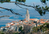
TOWN OF KRK
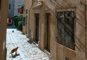 The
ancient Curicum, Frankopan castle, seat of the diocese, numerous
valuable monuments of culture, the famous Krk summer fair, the
secular tourist tradition, music and other festivals and programmes,
are part of the varied offering of the Town of Krk. Recreation is
offered in no smaller diversity and extent. Walks are arranged
towards the old part of the town, the promenade along the coast, but
also to the Prnib peninsula and to the town’s wider surroundings. We
single out: Easy walks along the Prniba peninsula (surface area: 1.5
km2) southeast of the town, for a length of 7.5 km, in the pine
trees, holly trees and underbrush to the bays of St. Mikula, Valunt
and St. Danijel. Particularly impressive is the isolated small
church of St. Krševan, an exceptional architectural gem in the
preserved Krk environment, today a pasture ground, relatively far
from the inhabited places.
The
ancient Curicum, Frankopan castle, seat of the diocese, numerous
valuable monuments of culture, the famous Krk summer fair, the
secular tourist tradition, music and other festivals and programmes,
are part of the varied offering of the Town of Krk. Recreation is
offered in no smaller diversity and extent. Walks are arranged
towards the old part of the town, the promenade along the coast, but
also to the Prnib peninsula and to the town’s wider surroundings. We
single out: Easy walks along the Prniba peninsula (surface area: 1.5
km2) southeast of the town, for a length of 7.5 km, in the pine
trees, holly trees and underbrush to the bays of St. Mikula, Valunt
and St. Danijel. Particularly impressive is the isolated small
church of St. Krševan, an exceptional architectural gem in the
preserved Krk environment, today a pasture ground, relatively far
from the inhabited places.
|
|
Required time:
one hour and 30 minutes - path Krk - Lamartin - Krk - path Krk - Sv. Juraj - Krk - path Linardići – St. Krševan church - path to the Čavlena bay (to the highest oak trees on the island) the paths’ length is from 8 to 10 km on average, and the expected walking time is approximately three hours. |
|
|
Procure the prospectus Prniba Promenade |
|
|
Town of Krk
Tourism Office phone 051/221 414 www.tz-krk.hr tz@tz-krk.hr |
TOURIST TRACKS OF BAŠKA AND ITS SURROUNDINGS
 On
the southeastern part of the island of Krk, in the northern part of
Baška draga, lies the place and the port of Baška. Owing to its
location, the long beach and its valuable heritage, Baška is a place
of extraordinary appeal. Here, with the assistance of Czech tourists
and guides, the existing paths were developed and marked as tourist
tracks, among the first ones in Kvarner. The total of 16 marked
tracks, 85 km long, has been classified in four categories:
non-demanding, demanding, semi-demanding and very demanding. The
tracks’ difficulty depends on the type of ground, the difficulty of
the ascent and other factors. Nondemanding tracks extend for a
length of 2 to 3.5 km and may be passed in approximately one hour
and twenty minutes, while the very demanding ones in some localities
- though shorter, will require a longer walking time. The 16 marked
tracks offer the possibility to visit the most important places and
localities of Bašćanska draga (Batomalj, Jurandvor, Draga Bašćanska)
and monuments of exceptional historical value such as the church of
St. Lucy (Sv. Lucije) (11th century) in which the best known
epigraphical monument of Croatian literature - Bašćanska ploča is
kept (the Baška stone tablet). Bašćanska ploča dates back to the
year 1100 and the church of St. Mary Majke Božje na Gorici (15th
century), the biggest sanctuary in the Krk diocese, is also located
here.
On
the southeastern part of the island of Krk, in the northern part of
Baška draga, lies the place and the port of Baška. Owing to its
location, the long beach and its valuable heritage, Baška is a place
of extraordinary appeal. Here, with the assistance of Czech tourists
and guides, the existing paths were developed and marked as tourist
tracks, among the first ones in Kvarner. The total of 16 marked
tracks, 85 km long, has been classified in four categories:
non-demanding, demanding, semi-demanding and very demanding. The
tracks’ difficulty depends on the type of ground, the difficulty of
the ascent and other factors. Nondemanding tracks extend for a
length of 2 to 3.5 km and may be passed in approximately one hour
and twenty minutes, while the very demanding ones in some localities
- though shorter, will require a longer walking time. The 16 marked
tracks offer the possibility to visit the most important places and
localities of Bašćanska draga (Batomalj, Jurandvor, Draga Bašćanska)
and monuments of exceptional historical value such as the church of
St. Lucy (Sv. Lucije) (11th century) in which the best known
epigraphical monument of Croatian literature - Bašćanska ploča is
kept (the Baška stone tablet). Bašćanska ploča dates back to the
year 1100 and the church of St. Mary Majke Božje na Gorici (15th
century), the biggest sanctuary in the Krk diocese, is also located
here.
 MOUNTAIN
TRACKS ON OBZOV
MOUNTAIN
TRACKS ON OBZOV
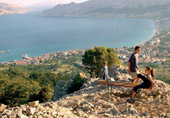
The highest peak on the island of Krk, Obzov (569m), the sixth peak
by height on the Croatian islands, may be reached from several
points of departure. Obzova is a hillock on the big Karst plateau
that the millenial presence of the «bura» wind stripped bare and
presented with many cracks and with only a few round meadows, fenced
by drywalls. The view from the top is something that really has to
be experienced. The most frequent points of departure are Treskavac
(Malmašuta) or Draga Bašćanska (possible departures also from Stara
Baška and Punat). Climbs should not be undertaken during the
scorching summer heat.
Recommendation:
- wear hiking boots
- bring dry food, drinkable water or other refreshments along
- undertake the more demanding tracks in groups
Some tracks end in the picturesque sea bays that give the
possibility of pleasant bathing, others reach belvederes offering
exceptional views (Bag, 185 m, Zakam, 194 m, Stražice, 372 m, Veliki
Hlam, 484 m). The more demanding ones lead, either through climbs or
steep descents, to the Vinodol Channel and offer a view on the town
of Senj, or on the other side, of Kvarnerić, Stara Baška. Return to
the point of departure is also possible by taxi boat. Two of these
tracks lead to the highest peak of the island of Krk. We recommend
the track no. 7, called “Way to the Moon” promenade.
|
|
Required time: - Treskavac (319 m) – Obzova one hour and 30minutes - Draga Bašanska – Obzova 2 hours and 30 minutes - Vaclavov put: (track no. 14) 4 hours |
|
|
Procure the map of promenades, the guidebook of Opatija and Sveta Lucija, the guidebook of the Baška church and chapel |
|
|
Baška
Municipality Tourism Office phone 051/856 817 www.tz-baska.hr tz-baska@ri.t-com.hr |
TRACKS OF OMIŠALJ AND NJIVICE
 In
the northwestern part of the island of Krk, on the Vela sten hill,
82 metres above the Omišalj Bay, stands the town of Omišalj. The
story of its civilization dates back to prehistoric times. The major
settlements that were built up in the area of Omišalj and Njivice
developed their fishermen roots into a significant tourist activity.
In terms of parochial, territorial-administrative, and today also
tourist-organization, Omišalj and Njivice represent a single entity.
Walking is possible in three directions that lead to historical
monuments, to the Krk natural wood landscapes and the relaxing
promenades along the seaside (lungomare).
In
the northwestern part of the island of Krk, on the Vela sten hill,
82 metres above the Omišalj Bay, stands the town of Omišalj. The
story of its civilization dates back to prehistoric times. The major
settlements that were built up in the area of Omišalj and Njivice
developed their fishermen roots into a significant tourist activity.
In terms of parochial, territorial-administrative, and today also
tourist-organization, Omišalj and Njivice represent a single entity.
Walking is possible in three directions that lead to historical
monuments, to the Krk natural wood landscapes and the relaxing
promenades along the seaside (lungomare).
FULFINUM-MIRINE
 From
Omišalj, one shoud head by foot to the southwest towards the Sepen
bay, the first-class archeological locality Fulfinum-Mirine. The
toponym Podokladi hides the remnants of the ancient town Fulfinum
(1st century), built for the Roman military veterans. This was a
town with complete urban facilities (forum, basilica, port
installations, spa, acquaduct, etc.). A great part of this space is
still undiscovered and unexplored. To the east of the site, on the
toponym Mirina, walls, remnants of the big early Christian basilica
from the end of the 5th or the beginning of the 6th century are
visible. The building is also mentioned as the Benedictine monastery
St. Nikola that was abandoned in the 15th century.
From
Omišalj, one shoud head by foot to the southwest towards the Sepen
bay, the first-class archeological locality Fulfinum-Mirine. The
toponym Podokladi hides the remnants of the ancient town Fulfinum
(1st century), built for the Roman military veterans. This was a
town with complete urban facilities (forum, basilica, port
installations, spa, acquaduct, etc.). A great part of this space is
still undiscovered and unexplored. To the east of the site, on the
toponym Mirina, walls, remnants of the big early Christian basilica
from the end of the 5th or the beginning of the 6th century are
visible. The building is also mentioned as the Benedictine monastery
St. Nikola that was abandoned in the 15th century.
|
|
Time required: -Omišalj - quay - Pesja - Mirine, Fulfinum -30 minutes -Omišalj – Path Konska - Buč - Fortičina - Mirine - Fulfinum - 25 minutes |
|
|
Procure the prospectus Fulfinum - Mirine and the map of the hiking tracks |
NJIVICE HIKING TRACKS
From the Njivice motorcamp there are marked hiking tracks directly
towards the Cerova hills (58m), Veli vrh (69m), Vršek (52m) and the
Dražica, Dumboka and Blatna bays. They are divided into three types:
the main and circular path and paths towards the sea (branch roads
from the main track), for less demanding walks.
|
|
Time required: main track 2 hours circular track 45 minutes tracks to the sea 20 minutes |
|
|
Procure the map of hiking tracks in Njivice |
PROMENADES ALONG THE SEASIDE
 Traced
along the sea coast, along the settlements’ quays, their origin lies
in tourism. Those in Njivice, in particular, lead to some
restaurants with excellent gastronomic offerings. In Njivice this is
the direction from the motor camp to the Kijac Bay. It is linked to
the hiking track for Malinska. In Omišalj this is the route from
hotel Adriatic to the Pesja bay.
Traced
along the sea coast, along the settlements’ quays, their origin lies
in tourism. Those in Njivice, in particular, lead to some
restaurants with excellent gastronomic offerings. In Njivice this is
the direction from the motor camp to the Kijac Bay. It is linked to
the hiking track for Malinska. In Omišalj this is the route from
hotel Adriatic to the Pesja bay.
Promenade through the park Dubec, Omišalj
With a length of 995 m and a surface area of 18 km2 extends a park
area full of paths, resting places, belvederes and varied
vegetation. Time required: 15 minutes
|
|
Walking time: - lungomare Njivice: 45 minutes - lungomare Omišalj: 20 minutes - promenade Dubec: 15 minutes |
|
|
Procure the map of Njivice and Omišalj |
|
|
Njivice-Omišalj Tourism Office Omišalj, phone 051/ 841 042 tzo-njivice@ri.t-com.hr Njivice, phone 051/846 243 www.tz-njivice-omisalj.hr |
DUBAŠNICA TRACKS
MALINSKA
 Dubašnica
is a spacious, verdant, fertile and wooded area opening onto the
Rijeka Bay. Its name originates from the oak woods (dub = oak tree),
that are also complemented by woods of oriental hornbeam. At the
beginning of the 15th century, this area was inhabited by many
families whose names have been inherited by the current settlements
of Vantačići, Turčići, Zidarići, Milčetići, Milovčići, Bogovići,
Radići, Maršići, Kremenići, gombići, Oštrobradići, Ljutići,
Barušići... In the tourism-development period (at the end of the
19th century) Malinska - a port for timber loading and unloading was
transformed in the principal centre of the Dubašnica area and almost
ousted the name Dubašnica from geographical and other terms. The
search of new «contents» began to be felt in the area. The Dubašnica
tracks are full of agricultural traces, one can still hear the
almost forgotten bleating of flocks of sheep and be a witness to the
visible and recognizable ethnic and religious identity here.
According to their level of difficulty, the tracks are classified
into those stretching along the seaside and those that stretch
around the hinterland.
Dubašnica
is a spacious, verdant, fertile and wooded area opening onto the
Rijeka Bay. Its name originates from the oak woods (dub = oak tree),
that are also complemented by woods of oriental hornbeam. At the
beginning of the 15th century, this area was inhabited by many
families whose names have been inherited by the current settlements
of Vantačići, Turčići, Zidarići, Milčetići, Milovčići, Bogovići,
Radići, Maršići, Kremenići, gombići, Oštrobradići, Ljutići,
Barušići... In the tourism-development period (at the end of the
19th century) Malinska - a port for timber loading and unloading was
transformed in the principal centre of the Dubašnica area and almost
ousted the name Dubašnica from geographical and other terms. The
search of new «contents» began to be felt in the area. The Dubašnica
tracks are full of agricultural traces, one can still hear the
almost forgotten bleating of flocks of sheep and be a witness to the
visible and recognizable ethnic and religious identity here.
According to their level of difficulty, the tracks are classified
into those stretching along the seaside and those that stretch
around the hinterland.
Walking time:
![]() Malinska
- cape Čuf 45 minutes
Malinska
- cape Čuf 45 minutes
Malinska – Vantačići 45 minutes
Porat - Sv. Martin 1 hour and 25 minutes
PROMENADES ALONG THE SEASIDE
The coastal path Rajska cesta (Road of Paradise) is the best known
promenade, traced towards the coast and the bathing resorts Haludovo
and Njivice even before World War II. It is intended for all types
of hikers, and besides wood landscapes, it also stretches along the
numerous bays and beaches. The second one connects Malinska and
Vantačići and leads to Porat, 3 km away, and to the monastic church
of St. Marija Magdalena of the Tertiary Franciscans (Glagolitic
priests) (15th century). The valuable polyptych (1556), olive
grinder, museum and collection of stone monuments «lapidarij» with
copies of the oldest Croatian glagolitic inscriptions are kept in
the monastery. The path along the seaside from Porat to the Bay of
St. Martin is somewhat more demanding, since it also comprises less
accessible terrain, offering in return preserved nature sights and a
very impressive view of the sea.
 HIKING
TRACKS
HIKING
TRACKS
These are easy and non-demanding paths that intersect the area of
Dubašnica connecting the villages, the so called «drmuni» and votive
localities. They stretch from the hills, belvedere Fumak (61 m)
overlooking the Čavlena Bay t o the orientation point of the
Northern part of Krk, the Church of St. Peter (252 m), above
Gabonjin in the Dobrinj area, up to the church and settlement St.
Vid - Miholjice. The paths on the map have been marked in yellow and
they touch the picturesque old graveyard, adjacent to which until
1855 stood the parish church (later on it was transferred to
Bogovići), a trace of which is the mighty stone bell tower (1618),
the votive crucifix and the stone Way of the Cross on the hill Fumak
and the one on the crossroads Bogovići- St. Anton - Milovčići, pass
along the votive chapel of St. Ivan de Mathe (Matahara) in the
vicinity of Oštrobradić, built with the support of Dubašnica
emigrants to America and to the famous small church of St. Petar na
Verhu. 41
|
|
Walking time: - Fumak – old cemetery o ne hour and 25 minutes - Old cemetery - Oštrobradići one hour and 15 minutes - Oštrobradići - Sv.Petar one hour and 25 minutes - Sv. Petar- Sv. Vid - Miholjice one hour and 35 minutes |
|
|
Procure the prospectus of Malinska promenades and hiking paths. |
|
|
Malinska
Municipality Tourism Office Phone 051/859 207, 858 254 tzo-malinska@ri.t-com.hr www.tz-malinska.hr |
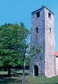
VRBNIK PATHS AND GORGES
 In
the central part of the eastern coast of the island of Krk, 49 m
above the sea, on the foundations of another Krk prehistoric fort,
stands the town of Vrbnik. This town, which has been exhibiting its
steadiness for 900 years, is famous as a town-castle, a town of
farmers, shepherds, excellent wine-growers, confraternities, of the
famous library, old Slavic liturgies, priests and artists. Vrbnik
will unveil its town streets, offer its Karst surroundings full of
the fragrances of aromatic plants and its fertile, rich vineyards to
the curious traveller. The Vrbnik Statutes square is the starting
point towards all directions – either towards the narrow street «all
around» (okolo-naokolo) the town or to isolated capes and sea bays,
to vineyards or pasture grounds in the hinterland. The target
destination of the majority of routes are first of all
historical-sacral buildings preserved to a great extent in the town,
while those in the surroundings are mostly in a dilapidated state.
The town streets lead to the parish church St. Marija of Uznesenja
(11th/ 12th century), the Church of St.
In
the central part of the eastern coast of the island of Krk, 49 m
above the sea, on the foundations of another Krk prehistoric fort,
stands the town of Vrbnik. This town, which has been exhibiting its
steadiness for 900 years, is famous as a town-castle, a town of
farmers, shepherds, excellent wine-growers, confraternities, of the
famous library, old Slavic liturgies, priests and artists. Vrbnik
will unveil its town streets, offer its Karst surroundings full of
the fragrances of aromatic plants and its fertile, rich vineyards to
the curious traveller. The Vrbnik Statutes square is the starting
point towards all directions – either towards the narrow street «all
around» (okolo-naokolo) the town or to isolated capes and sea bays,
to vineyards or pasture grounds in the hinterland. The target
destination of the majority of routes are first of all
historical-sacral buildings preserved to a great extent in the town,
while those in the surroundings are mostly in a dilapidated state.
The town streets lead to the parish church St. Marija of Uznesenja
(11th/ 12th century), the Church of St.
 John
the Baptist (St. Ivan Krstitelj), Baćin dvor, Frankopan buildings
(16th century) today transformed in a cafè gallery, to the stone
sacral collection Destinac, to «Klančić», the narrowest street in
the world. They lead to the church of St. Marija od Zdravlja (1859)
and the Park Gospoj from which a marvellous view extends on the
Vinodol channel and the littoral. Outside the town, paths and passes
head towards pasture grounds and vineyards. In each new season,
fragrances and colours of autochtonous plants translate in complete
and unspeakably pleasant sensations. Particularly worthy of mention
is the month of May, when the countryside is dappled with the purple
of sage flowers.
John
the Baptist (St. Ivan Krstitelj), Baćin dvor, Frankopan buildings
(16th century) today transformed in a cafè gallery, to the stone
sacral collection Destinac, to «Klančić», the narrowest street in
the world. They lead to the church of St. Marija od Zdravlja (1859)
and the Park Gospoj from which a marvellous view extends on the
Vinodol channel and the littoral. Outside the town, paths and passes
head towards pasture grounds and vineyards. In each new season,
fragrances and colours of autochtonous plants translate in complete
and unspeakably pleasant sensations. Particularly worthy of mention
is the month of May, when the countryside is dappled with the purple
of sage flowers.
|
|
Vrbnik
Municipality Tourism Office phone 051/857 479 www.vrbnik.net tz@vrbnik.net |
TO THE CHURCH OF St. JURAJ
South of Vrbnik, on the cape of St. Juraj, in the homonymous bay,
the remnants of the small church dedicated to St. Juraj may be
found. The image of St. Juraj as well as the illustration of the
vessel, the oldest preserved one on the Croatian coast (12th/13th
century) are discernible from the church walls.
![]() Walk
duration: about 2 hours
Walk
duration: about 2 hours
TO THE CHURCH OF St. MARKO
In order to reach the ruins of the small church St. Marko (Marek)
one should head to the village of Risika, then turn right to the
parish church and reach the homonymous bay with the beach that is a
favourite destination of many bathers. A peculiarity here are the
bushes of the evergreen strawberry tree (Arbutus unedo).
![]() Walk
duration: 2 hours
Walk
duration: 2 hours
 TO
GRADAC
TO
GRADAC
In order to reach the Krk princes’ ruins, one should pass
along the fringes of Vrbničko polje, to the village of
Garica, and there enquire as to the onward route.
![]() Walk
duration: 2 hours
Walk
duration: 2 hours
IN THE DOBRINJ AREA
 The
Dobrinj area is a spacious, mildly undulated green area on the
northeastern part of the island of Krk occupied by the villages: Či
ići, Dobrinj, Gabonjin, Gostinjac, Gornja and Donja Hlapa, Klanice,
Klimno, Kras, Meline, Polje, Rasopasno, Rudine, Soline, Su an, Sv.
Ivan, Sv. Vid, Šilo, Tribulje, etilac, Županje and the town of
Dobrinj, the oldest Croatian town on the island of Krk, cultural and
administrative centre of the entire area.
The
Dobrinj area is a spacious, mildly undulated green area on the
northeastern part of the island of Krk occupied by the villages: Či
ići, Dobrinj, Gabonjin, Gostinjac, Gornja and Donja Hlapa, Klanice,
Klimno, Kras, Meline, Polje, Rasopasno, Rudine, Soline, Su an, Sv.
Ivan, Sv. Vid, Šilo, Tribulje, etilac, Županje and the town of
Dobrinj, the oldest Croatian town on the island of Krk, cultural and
administrative centre of the entire area.
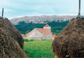
The area of Dobrinj is an autochtonous, rural landscape, with ethnological heritage, preserved environment, varied plant communities, underground Karst phenomena (Biserujka cave), protected bays with curative mud and a pleasant climate. In this area, some sixty kilometres of sandy paths have been marked. Their course is circular. The departure point is also the point of arrival. It may be passed in one day, or, in an easier way – as one prefers – from one point to the other.
There are eight marked points (Šilo, estilac, Gostinjac, Sveti Vid, Dobrinj, Gornja Hlapa, upanje, Šilo), with different tour lengths. In each control point, a photograph should be taken or a stamp affixed. The award for the traversed path is the numerated badge and the opportunity to register in the Visitors’ Book.
 Along
these fifty kilometres we shall pass through protected sea bays, the
Stipanjska Bay, the gentle, shallow Soline Bay, stop near the ruins
of the Roman villa in Šilo, near the churches of St. Marija of
Porođenja in Polje (1876), St. Martin in Gostinjac (1576), the early
romanic St. Vid (1100, endownment of the “famous Dragoslav”), St.
Klement in Klimno (1381, the Renaissance carving, St. Filip and
Jakov in Soline (1382), the Dobrinj parish church of St. Stjepan
(1100), St. Trinity (1480, pučki St. Antuna) along the park
Jardin... The Dobrinj path will lead us to Polje, to the nuns’
monastery and the nursing home in the beautiful locality of Zviranj,
to valuable sacral and ethnological collections, to the belvederes
“Zemljine” in the vicinity of the Dobrinj marketplace and the
bell-tower from which the bell ringing reverberates through the
entire area of Dobrinj and beyond, then to the mythical hill of St.
Juraj (327 m). The paths lead through a wood covered by unique wood
vegetation. Here grows the durmast oak-tree (Quercus petraea), hop
hornbeam (Carpinus betulus), sweet chestnut trees(Castanea sativa),
lime trees (Tilia cordata), sycamore (Acer pseudopatanus)... all
species growing in the mountain woods of the mainland, but on no
other Adriatic island – except for Krk.
Along
these fifty kilometres we shall pass through protected sea bays, the
Stipanjska Bay, the gentle, shallow Soline Bay, stop near the ruins
of the Roman villa in Šilo, near the churches of St. Marija of
Porođenja in Polje (1876), St. Martin in Gostinjac (1576), the early
romanic St. Vid (1100, endownment of the “famous Dragoslav”), St.
Klement in Klimno (1381, the Renaissance carving, St. Filip and
Jakov in Soline (1382), the Dobrinj parish church of St. Stjepan
(1100), St. Trinity (1480, pučki St. Antuna) along the park
Jardin... The Dobrinj path will lead us to Polje, to the nuns’
monastery and the nursing home in the beautiful locality of Zviranj,
to valuable sacral and ethnological collections, to the belvederes
“Zemljine” in the vicinity of the Dobrinj marketplace and the
bell-tower from which the bell ringing reverberates through the
entire area of Dobrinj and beyond, then to the mythical hill of St.
Juraj (327 m). The paths lead through a wood covered by unique wood
vegetation. Here grows the durmast oak-tree (Quercus petraea), hop
hornbeam (Carpinus betulus), sweet chestnut trees(Castanea sativa),
lime trees (Tilia cordata), sycamore (Acer pseudopatanus)... all
species growing in the mountain woods of the mainland, but on no
other Adriatic island – except for Krk.
|
|
Duration: - Šilo – Žestilac one hour and 30 minutes - Žestilac - Gostinjac 30 minutes - Gostinjac - Sv. Vid 40 minutes - Sv. Vid - Dobrinj 10 minutes - Dobrinj - Gornja Hlapa 40 minutes - Gornja Hlapa – upanje 35 minutes - Županje – Šilo one hour |
THE GLAGOLYTHIC PATH
 The
small St. Petar’s Church (1279) on the western part of the island of
Krk, endowment of two sisters according to the legend, may be
reached from the village of Gabonjin via a path along which 37 stone
plates have been recently placed, with engraved messages and a
glagolythic alphabet. The church dominates the landscape and
represents a secular orientation point but also a guard house (hence
the name St. Petar na Stra išu (252 m), (stra a=guard). It is worth
climbing St. Petar, particularly on St. Peter’s Day (29th of June)
when, in the area in front of the church, celebrations are held.
The
small St. Petar’s Church (1279) on the western part of the island of
Krk, endowment of two sisters according to the legend, may be
reached from the village of Gabonjin via a path along which 37 stone
plates have been recently placed, with engraved messages and a
glagolythic alphabet. The church dominates the landscape and
represents a secular orientation point but also a guard house (hence
the name St. Petar na Stra išu (252 m), (stra a=guard). It is worth
climbing St. Petar, particularly on St. Peter’s Day (29th of June)
when, in the area in front of the church, celebrations are held.
|
|
Walking time: - Gabonjin - Sv Petar 20 minutes - Ljutići - Sv. Petar one hour and 25 minutes - Rasopasno - Sv. Petar 45 minutes |
|
|
Procure the guidebook «Putovima Dobrinjštine» |
|
|
Dobrinj
Municipality Tourism Office phone 051/852 107, 091 505 35 95 tzo-dobrinj@ri.t-com.hr www.tzo-dobrinj.hr |
PUNAT PATHS AND THE KOŠLJUN ISLET
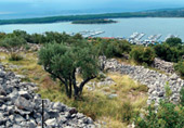 The
soutwestern coast of the island of Krk, precisely the eastern part
of the shallow Puntarska draga, separated from the Krk Bay by the
Prniba peninsula, belongs to the settlement and port of Punat.
Today, it is one of the leading centres in Croatian nautical tourism
(Blue flag), famous also for its high quality olive oil products
(Olives Days are held each year in October). Punat (first mentioned
in 1377) is proud of its other values as well. The most important of
these are the St. Trinity Church (1777) and Maggiotto’s painting of
St. Ivan’s sermon, on the main altar, the sculpture of Ana Samotreća
(15th century), the old houses for the common people (18th century),
the toš olive grinder (18th century) and the Toš Gallery. Special
appeal to Punat is also given by the Košljun islet, “island in the
island”, a wood reserve and cultural monument. Eight kilometres
southeast of Punat, below the white limestone rocks and protected
from the «bura» wind, sits the quiet settlement of Stara
The
soutwestern coast of the island of Krk, precisely the eastern part
of the shallow Puntarska draga, separated from the Krk Bay by the
Prniba peninsula, belongs to the settlement and port of Punat.
Today, it is one of the leading centres in Croatian nautical tourism
(Blue flag), famous also for its high quality olive oil products
(Olives Days are held each year in October). Punat (first mentioned
in 1377) is proud of its other values as well. The most important of
these are the St. Trinity Church (1777) and Maggiotto’s painting of
St. Ivan’s sermon, on the main altar, the sculpture of Ana Samotreća
(15th century), the old houses for the common people (18th century),
the toš olive grinder (18th century) and the Toš Gallery. Special
appeal to Punat is also given by the Košljun islet, “island in the
island”, a wood reserve and cultural monument. Eight kilometres
southeast of Punat, below the white limestone rocks and protected
from the «bura» wind, sits the quiet settlement of Stara
 Baška.
Hikers and recreationists are offered sphepherds’ tracks and seaside
promenades, traced in the ancient times and well marked today, as
well as the Košljun islet, with its many attractions.From Punat,
paths climb up to the highest peaks of the island of Krk: Veli vrh
(541 m), Brestovica (558 m), Obzova (568 m), Zminj (537 m) and Veli
hlam (482 m). There are three starting points: Prgon, Ricompi and
Zarimon; from Stara Baška one for Punat and two for Batomalj in
Bašćanska draga. It is also possible to walk from one destination to
the other without reaching the highest peaks of the island. The
difficulty of the paths ranges from medium to high because of the
ascents, particularly those in Stara Baška. At the starting points,
tables have been set up, containing information about the walk’s
direction and expected duration. The paths are well-marked with
colours (red and white, blue and white, green and white) and the
marks have been set up each 20 to 50 metres. Directions are marked
on large stones on the crossroads. The Punat promenades extend on
the part from Prgon to Kanajt, and we recommend to proceed along the
road, to the Old Croatian church of St. Dunat (9th century) and from
the centre of Punat through the Debilj cape to Camp Konobe.
Baška.
Hikers and recreationists are offered sphepherds’ tracks and seaside
promenades, traced in the ancient times and well marked today, as
well as the Košljun islet, with its many attractions.From Punat,
paths climb up to the highest peaks of the island of Krk: Veli vrh
(541 m), Brestovica (558 m), Obzova (568 m), Zminj (537 m) and Veli
hlam (482 m). There are three starting points: Prgon, Ricompi and
Zarimon; from Stara Baška one for Punat and two for Batomalj in
Bašćanska draga. It is also possible to walk from one destination to
the other without reaching the highest peaks of the island. The
difficulty of the paths ranges from medium to high because of the
ascents, particularly those in Stara Baška. At the starting points,
tables have been set up, containing information about the walk’s
direction and expected duration. The paths are well-marked with
colours (red and white, blue and white, green and white) and the
marks have been set up each 20 to 50 metres. Directions are marked
on large stones on the crossroads. The Punat promenades extend on
the part from Prgon to Kanajt, and we recommend to proceed along the
road, to the Old Croatian church of St. Dunat (9th century) and from
the centre of Punat through the Debilj cape to Camp Konobe.
|
|
Expected walk
duration: Prgon - Kalabrin - Veli vrh one hour and 50 minutes Ricomp - Runtel - Veli vrh 2 hours Zarimon - Suha lokva - Veli vrh 2 hours and 50 minutes Zarimon- Runtel - Kalabrinj – Prgon 2 hours and 25 minutes Prgon – Kanajt 25 minutes |
|
|
Procure the map of the Shepherds’ path and of Punat |
ISLET OF KOŠLJUN
Small by size (0,06 km2), and great in terms of offer, only a few
metres above sea level and only 190 metres away from the mainland,
it is an area of luxuriant vegetation: flowering ash (Fraxinus
ornus), laurel (Laurus nobilis), holly oak (Quercus ilex),
montpellier maple (Acer monspessulanum). The Franciscan Berard Bari
has managed to count as many as 540 plant species and classify them
in 111 families, found as much as 151 mushroom species from 33
families. Various species of birds live in Košljun, predominantly
song-birds. At the same time, Košljun is a Franciscan monastery
(1447) that contains the famous library consisting of 30.000
volumes, incunabula, glagolithic documents, valuable atlases (16th
century). Once seat of the Croatian secondary school (since 1894),
today keeps an exceptionally rich range of works of art, music and
ethnographic collections, a beautiful crèche (16th century), the
miraculous crucifix. There are also several wooden chapels here:
Chapel of Bethlehem (1651) St. Križ (1579), St. Franjo (1654), the
Lurdska spilja cave (1914)...
![]() Punat
Municipality Tourism Office
Punat
Municipality Tourism Office
phone 051/854 970, 854 860
www.tzpunat.hr tz-punat@ri.t-com.hr
