
GORSKI KOTAR
Brod Moravice, Čabar, Delnice,
Fužine, Lokve, Mrkopalj, Ravna
Gora, Skrad, Vrbovsko
 No
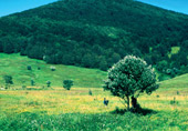
matter how many times you’ve visited Gorski kotar, this always
represents an experience of incontestable attractions, of preserved
wood areas, picturesque valleys, clear rivers and lakes, the Risnjak
National Park, nature reserves, monuments of nature and of cultural
heritage, of rural and traditional values and - most of all - of
sincere and cordial hospitality that is provided by the Gorski Kotar
people. The experience of the almost mythical landscapes inspires
happiness, offering peace and relaxation. Gorski kotar is a great
plateau between Hrvatsko primorje and Pokuplje, about 35 km
No
matter how many times you’ve visited Gorski kotar, this always
represents an experience of incontestable attractions, of preserved
wood areas, picturesque valleys, clear rivers and lakes, the Risnjak
National Park, nature reserves, monuments of nature and of cultural
heritage, of rural and traditional values and - most of all - of
sincere and cordial hospitality that is provided by the Gorski Kotar
people. The experience of the almost mythical landscapes inspires
happiness, offering peace and relaxation. Gorski kotar is a great
plateau between Hrvatsko primorje and Pokuplje, about 35 km
 wide
and 800 metres high. The steep step above the littoral represents a
boundary on one side, while the other one is almost linked to the
area of Pokuplje and the Karlovac area. The climate is continental:
mountainous, harsh with short and fresh summers and long winters,
average temperatures of 7oC (January –2 oC, July 17.1 oC) are its
main features. With an abundance of natural and historical
attractions on a relatively small area, it is an area of exceptional
wood (55%) meadow and pasture ground (32%), an area that in terms of
relief and climate is different, but as to population, economy and
culture is very close to Kvarner. The Risnjak National Park, the
strict nature reserve of Bijele and Samarske stijene, the special
reserves of Vražji prolaz and Zeleni vir (geomorphological), Debela
lipa - Velika rebar (wood vegetation), the Japlenški vrh and
Golubinjak woods, the monuments of nature (geomorphological)
Lokvarska pećina, the Kupa source (hydrological) Međedova stara hiša
(some specimens), the park in the vicinity of the Severin castle
(park architecture), the protected landscape of Kamačnik, historic
units, ethnological zones, memorial, sacral and other heritage are
part of this rich offering.
wide
and 800 metres high. The steep step above the littoral represents a
boundary on one side, while the other one is almost linked to the
area of Pokuplje and the Karlovac area. The climate is continental:
mountainous, harsh with short and fresh summers and long winters,
average temperatures of 7oC (January –2 oC, July 17.1 oC) are its
main features. With an abundance of natural and historical
attractions on a relatively small area, it is an area of exceptional
wood (55%) meadow and pasture ground (32%), an area that in terms of
relief and climate is different, but as to population, economy and
culture is very close to Kvarner. The Risnjak National Park, the
strict nature reserve of Bijele and Samarske stijene, the special
reserves of Vražji prolaz and Zeleni vir (geomorphological), Debela
lipa - Velika rebar (wood vegetation), the Japlenški vrh and
Golubinjak woods, the monuments of nature (geomorphological)
Lokvarska pećina, the Kupa source (hydrological) Međedova stara hiša
(some specimens), the park in the vicinity of the Severin castle
(park architecture), the protected landscape of Kamačnik, historic
units, ethnological zones, memorial, sacral and other heritage are
part of this rich offering.
The number of mountain tracks is endless. We shall single out only some of them.
THE BROD MORAVICE AREA
 In
the northern part of Gorski kotar is located an area representing a
specific tourist zone, not only owing to its favourable climatic and
health conditions, but also due to its numerous historic, sacral,
and ethnological features. This area is suitable for pleasant and
slow-pace walks with sightseeing of unique, protected cultural
resources and resting places in attractive belvederes overlooking
the Kupa river and the whole area. The best way is to come to the
municipal centre of Brod Moravice (609 m) first mentioned (1481) in
connection with Stjepan Frankopan, and start walking from the
secular lime tree (Lipica) and St. Nikola’s church (18th century)
with its bell-tower – once an important observation point - and
tower (17th century). The easy walks may be short or long, depending
on the destination, however the surrounding environment shall offer
a pleasant atmosphere, regardless of the length. There is a
graveyard in the vicinity, with the chapel of Sv. Rok (17th
century), Piljdak, and in less than half an hour you can reach the
protected ethnozone of Moravička Sela with the votive church of
Majka Božja Škapularska (17th century). Other protected zones follow
in a series: St. Andrija’s hill, then Delači, Maklen, Doluš, Gornji
Kuti, Colnari as well as specific buildings: the houses Delač (17th
century), Mance (18th century, in the village of Kuti) and
Ožani-Žižek (19th century), represent extraordinary examples of
Croatian rural architecture of that time and space”. From the
mountain tracks and belvederes, the most interesting spots are the
peaks at the fringes of the cut-in Kupa valley: Špičasti vrh (701 m,
in the direction of Kocijan), Medveje stene (towards Colnar), Orlove
stijene (569 m, towards Razdrto). Additionally, there is Levešni vrh
(735 m) overlooking the Kupa river, a peak covered by wood, Okruglja
(886 m, conical peak with luxuriant vegetation, towards Velika and
Mala Draga) then Parag, dominating the area. There is quite a number
of caves, among which the best known are Brlog, Gornji Brlog,
Maklenske jame and Ruda. Orlove stijene elevate up to the height of
300 metres above the Kupa. From the fenced concrete terrace, a view
extends over the Kupa canyon and the Slovene mountains Kočevske
planine. They are the control point of the Gorski Kotar Mountain
Path (Goranski planinarski put – GPP). Already by its name Špičasti
vrh (špičast=pointed), the peak speaks about its steep slopes
overlooking the Kupa valley. From the top, a view extends on
Drgomalj, Snježnik, Guslica, Slovenski Snježnik and Skradski vrh..
In
the northern part of Gorski kotar is located an area representing a
specific tourist zone, not only owing to its favourable climatic and
health conditions, but also due to its numerous historic, sacral,
and ethnological features. This area is suitable for pleasant and
slow-pace walks with sightseeing of unique, protected cultural
resources and resting places in attractive belvederes overlooking
the Kupa river and the whole area. The best way is to come to the
municipal centre of Brod Moravice (609 m) first mentioned (1481) in
connection with Stjepan Frankopan, and start walking from the
secular lime tree (Lipica) and St. Nikola’s church (18th century)
with its bell-tower – once an important observation point - and
tower (17th century). The easy walks may be short or long, depending
on the destination, however the surrounding environment shall offer
a pleasant atmosphere, regardless of the length. There is a
graveyard in the vicinity, with the chapel of Sv. Rok (17th
century), Piljdak, and in less than half an hour you can reach the
protected ethnozone of Moravička Sela with the votive church of
Majka Božja Škapularska (17th century). Other protected zones follow
in a series: St. Andrija’s hill, then Delači, Maklen, Doluš, Gornji
Kuti, Colnari as well as specific buildings: the houses Delač (17th
century), Mance (18th century, in the village of Kuti) and
Ožani-Žižek (19th century), represent extraordinary examples of
Croatian rural architecture of that time and space”. From the
mountain tracks and belvederes, the most interesting spots are the
peaks at the fringes of the cut-in Kupa valley: Špičasti vrh (701 m,
in the direction of Kocijan), Medveje stene (towards Colnar), Orlove
stijene (569 m, towards Razdrto). Additionally, there is Levešni vrh
(735 m) overlooking the Kupa river, a peak covered by wood, Okruglja
(886 m, conical peak with luxuriant vegetation, towards Velika and
Mala Draga) then Parag, dominating the area. There is quite a number
of caves, among which the best known are Brlog, Gornji Brlog,
Maklenske jame and Ruda. Orlove stijene elevate up to the height of
300 metres above the Kupa. From the fenced concrete terrace, a view
extends over the Kupa canyon and the Slovene mountains Kočevske
planine. They are the control point of the Gorski Kotar Mountain
Path (Goranski planinarski put – GPP). Already by its name Špičasti
vrh (špičast=pointed), the peak speaks about its steep slopes
overlooking the Kupa valley. From the top, a view extends on
Drgomalj, Snježnik, Guslica, Slovenski Snježnik and Skradski vrh..
|
|
Expected
walking time: - Brod Moravice - Šimatovo 2 hours - Šimatovo - Leveš vrh - Kupa valley - Goršeti - Brod Moravice 5 hours - Šimatovo - Leveš vrh - Šimatovo 1 hour and 30 min. - Brod Moravice - Gornji Kuti- slope Vršak - Maklen - Delači- Moravićka Sela - Špičasti vrh 1 hour and 30 min. - Gornja Dobra - Špičasti vrh - Brod Moravice 4 hours - Podstene - Špičasti vrh - Podstene 1 hour and 30 min. - Brod Moravice - Velike Drage - Razdrto – the hunting lodge Litori - Orlova stijena 2 hours - Brod Moravice - Gornji Kuti - Okrugljak - Orlova stijena - Razdrto 4 hours - Brod Moravice - Gornji Kuti - Okrugljak - Orlova stijena - Razdrto - Brod Moravice 6 hours - Brod Moravice - Gornji Kuti - Okrugljak - Gornji Kuti - Brod Moravice 6 hours |
|
|
Brod Moravice
Municipality Tourism Office phone 051/817 180 www.tz-brodmoravice.hr |
THE ČABAR AREA
The northwestern part of Gorski kotar, situated in the corner of the state boundaries, is an area of extraordinarily dense woods, genuine mountain features and attractions. Its heritage has been created by the numerous historic changes, wars and by newcomers. Prezid has inherited the Roman, Liburnian defence limes, but also the popular architecture protected as national heritage. Čabar, the manor of Petar Zrinski (1651), painters’ and other donations, Mali Lug legends on the hero Petar Klepac, Gerovo, once the centre of Gorski kotar, the famous parish (1504) and the votive, pilgrim’s church of Majka Božja Svetogorska Gerovo (584 m), Tršće (824 m), Plešce (322m), Prezid (764 m) and the centre Čabar (523 m) are mountain departure points for both easier and more demanding climbs, as well as for pleasant walks across wood landscapes and gentle slopes.
Among the tracks, the follwing ones
stand out:
- in Plešci (322 m) the path for Sveta gora (809 m), towards the
Gerovčica source, the Kupa source, and the «track of king Bela IV»
to reach Kraljev vrh (950 m) through Okrivje
- in Gerovo, the track for Sv. gora, to Hrib, for the Kupa source
(313 m) and Risnjak
- in Tršće the track to the rocks of Petrinska, Sokolanska stijena,
for Farjev laz and the peak Kraljev vrh
- in Čabar to the Čabranka source, to the belvedere Tropetske
stijene
- in Prezid the recreational track Trbuhovica (with positive energy
radiation).
After Trsat, Sveta gora is the
second pilgrims’ sanctuary in Primorje and Gorski kotar. The track
leading to the Čabranka source is one kilometre upstream,
overlooking the fish restaurant and the water pumping site. One
source is on the Croatian side and the other, larger one, on the
Slovene part. Sokolanska stijena (961 m) is a rocky barrier
overlooking the hamlet of Sokoli. Rudnik (1.052 m), with a
meadow on top offering views of the surrounding peaks and the
Slovene Snježnik, a ski resort in winter. Vražji vrtec (904 m)
is a peak overlooking the border crossing at Prezid with a view of
the village of Babno. Kozji vrh (927 m) opens a view on
Prezid, Slovenia and the Gorski kotar mountains. Under the peak
stands the small church of Majka Božja od Sedam žalosti. Milanov
vrh (1011 m) is an undulating plateau with a hunting lodge and a
fenced area for the breeding of does and also a memorial area.
Climbers lodgings and similar facilities
Climber’s lodging Frbežari (825 m), 21 beds, kitchen, power and
water supply
Hunting lodge Milanov vrh
|
|
Walk duration: - Čabar – Čabranka source 15 minutes - Gerovo – Donji Kupari 3 hours - Kupa source – Hrib Skednari – Kraljev vrh – Tršće 7 hours - Frbežari – Rudnik – Frbežari 2 hours - Frbežari – Sololanska stijena – Frbežari 2 hours - Frbežari – Kraljev vrh – Frbežari 1 hours and 15 minutes - Kraljev vrh – Čabar 1 hour and 30 minutes |
|
|
Čabar Tourism
Office phone 051/821 042 |
THE RAVNA GORA AREA
 Ravna
Gora (816 m) is a mountain settlement of newer formation, the
origins of which are linked to the construction of the Karolina road
(1725). Along this 6 km long road, today called Ivan Goran Kovačić
street, a settlement developed marked by the Emperor Joseph II
Charter, the status of priviledged free town (1785). It also boasts
a long elementary education tradition (1786), wind orchestra (1830),
significant timber industry tradition (six saw-mills from 1830),
advanced and socially focused community (1894) and hiking club
(1933). The Ravna gora inhabitants recommend the track «Ravnogorski
planinarski put», RGPP (1989) with twelve control spots for which
approximately 24 walking hours are required. The proposal of a
four-day tour looks therefore acceptable.
Ravna
Gora (816 m) is a mountain settlement of newer formation, the
origins of which are linked to the construction of the Karolina road
(1725). Along this 6 km long road, today called Ivan Goran Kovačić
street, a settlement developed marked by the Emperor Joseph II
Charter, the status of priviledged free town (1785). It also boasts
a long elementary education tradition (1786), wind orchestra (1830),
significant timber industry tradition (six saw-mills from 1830),
advanced and socially focused community (1894) and hiking club
(1933). The Ravna gora inhabitants recommend the track «Ravnogorski
planinarski put», RGPP (1989) with twelve control spots for which
approximately 24 walking hours are required. The proposal of a
four-day tour looks therefore acceptable.
- At the same, the control spots are marvellous attractions and they
are worth visiting.
They are:
- the peak «Kicljev vrh» (920 m) and the caves «Kicljeve jame» (800
m, Caves: Velika, Bijela i Mala, Crna jama with total length of
tunnels of approximately 1070 meters).
- Javorova kosa (1016 m), iron pyramid, a belvedere 13 metres high
with view of Gorski kotar and Slovenia, up to
 the
Karavanke.
the
Karavanke.
- Ruda -vijenac (899 m) spacious views, in May lilies of the valley
blossom here
- Ledena jama (1016 m), most beautiful in winter, with ice ornaments
- Božji studenac, a perpetual source and a curative source,
according to the legend, 10 minutes’ walk from the refuge of
Javorova kosa.
- Stara Sušica (742 m), a settlement six kilometres southeast of
Ravna Gora, famous for the Frankopan castle. Its present appearance
dates back to the 19th century, when its owner was Count Laval
Nugent.
- Turmin (1085 m), in May wild garlic blossoms here
- Višnjevica (1367 m), is the highest Ravna Gora mountain (known for
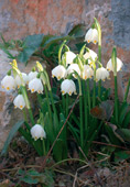
its snowdrops)
- Bjelolasica (1533 m), the highest Gorski kotar peak For those with
little time to spare, the suggested tour goes in two directions,
starting from the centre of Ravna Gora: to the top of Javorova kosa
(1016 m) and to the top of Turmin (1085 m). The Ravna Gora area
offers special, occasional programmes to nature lovers, called Wild
Fruit. It is a traditional ecological manifestation that - from May
to October – consists of educational, ethnologic and other
programmes.
 Peculiarity:
Precipice Pod Kosicom, 207 metres deep, with 737 metres of cave
tunnels
Peculiarity:
Precipice Pod Kosicom, 207 metres deep, with 737 metres of cave
tunnels
Mountain cottages: On Javorova kosa (1000 m), 10 beds, no electric
power, water from «Božji studenac» (10 minutes’ walk). Lokanda (963
m), 20 beds, kitchen, living room.
|
|
Ravna Gora
Municipality Tourism Office phone 051/818 351 www.tz-ravnagora.hr tzo-ravna-gora@ri.t-com.hr |
THE LOKVE AREA
 Lokve
is a settlement (723 m) situated in the homonymous valley, that was
mentioned for the first time in 1481, while 1906 marks the year when
the Village’s Embellishment Society was established. The Lokve
(Youth) Lake, the Lokve Cave, the Golubinjak wood, the protected
reserve of Debela lipa - Velika rebar are natural attractions linked
by hiking paths and promenades.
Lokve
is a settlement (723 m) situated in the homonymous valley, that was
mentioned for the first time in 1481, while 1906 marks the year when
the Village’s Embellishment Society was established. The Lokve
(Youth) Lake, the Lokve Cave, the Golubinjak wood, the protected
reserve of Debela lipa - Velika rebar are natural attractions linked
by hiking paths and promenades.
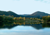
Path around the Lake
The Lokve artificial lake was created by the construction of the dam
(1955) on the river Lokvarka. Owing to interesting views, landscape
and permanent changes in the water level, it was proposed for the
category of significant landscape. It covers an area of 2.1 km2, its
depth amounts to about 40 metres, and extends to the foot of
Risnjak. The 17 km long path is easy to cross. A traditional hiking
tour has been organized around the lake annually since 1978. This
takes place at the beginning of August.
![]() Walking time: 3 hours
Walking time: 3 hours
Golubinjak paths
The Golubinjak wood is a protected area (1954), covering a surface
area of 51 hectares. The coniferous wood, the numerous karst
features, sinking holes, valuable animal and vegetal life, buildings
built in harmony with the environment, sports and recreational
grounds, works from the sculptural workshop, all this discreetly
fills the space that is unique and exceptionally attractive to begin
with. The paths, approximately 5 km long, have been traced along the
main wood attractions: the “wood queen”, a 200 year old fir-tree
(diameter 140 cm and height 40 metres), two caves: Ledena cave (110
metres long, with no dripstones with a lot of stones fallen in and
Golubinjak cave (15 metres long), named after the stock doves (dove
= golub) that gave the name to the wood, too. Golubinjak can also be
reached by car, but it is particularly pleasant to head there on
foot through the secular chestnut tree lined path (proposed for
protection) starting from from the centre of Lokve. The length is
about 2 kilometres.
![]() Walk
time:
Walk
time:
- the wood park Golubinjak about 45 minutes
- from the centre of Lokve to Golubinjak about 30 minutes
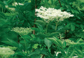
Flora: enchanter’s nightshade (Circaea alpina), alpine coltsfoot
(Homogyne sylvestris), stitchwort (Stellaria nemorum)... Fauna:
doormice (Myoxus glis), squirrels (Sciurus vulgaris), numerous
birds, butterflies, coleoptera
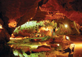
To the Lokvarka cave
From the centre of Lokve (or from Golubinjak) the Lokvarka cave
(Lipa), protected in the category of monuments of nature, can also
be reached by road (2 kilometres). The cave was discovered in 1911
and has been explored for a length of 1200 metres. Visitors can
sightsee for 900 metres, passing through three galleries (Šišmisa
/Bats’ hall , Plesna/ Dancing Hall and Crvena/ Red Hall), while the
fourth one (Virgin hall) is at speleologists’ disposal only and
subject to further research. In addition to the cave ornaments, a
peculiarity is represented by the stable temperature (from 6.5 to
8oC), and the difference in altitude between the entry point and the
last point accessible to the visitors is 140 metres. The cave’s age
is estimated at approximately 20 to 25 thousand years. The
sightseeing lasts about 40 minutes.
![]() Walk
time:
Walk
time:
- Lokve - Lokvarka cave about 30 minutes
We single out:
- the mini farm Lazac - Lokve – Lazac, approximately one hour’s walk
- walk along the lake in Mrzle Vodice and Carski most - the caves
Bukovac and Medvjeđa pećina, proposed in the category of monuments
of nature, habitat of rare cave fauna (locus typicus) of national
importance - due to the rugged terrain it is possible to visit the
special reserve Debela lipa - Velika rebar only if you have a guide.
|
|
Lokve
Municipality Tourism Office phone 831 250 www.tz-lokve.hr tzo-lokve@ri.t-com.hr |
THE SKRAD PATHS
 In
the central mountain area and the steep slopes of Skradski vrh, on
the road Lujzinska cesta (1809), lies Skrad (700 m), a settlement
known since the end of the 19th century, famous as a climatic
recovery and rest resort. Below Skrad, at the bottom of a canyon
valley (350 m deep) winding between the Skrad and Kupjak peaks, the
river Kupa receives the tributaries Kupica and Iševnica (created
from the potok Jasla and Curak). It is exactly this area that
creates one of the most significant natural phenomena in our
country. There is a special geomorphological reserve here, Vra iji
prolaz with Mu eva hi ica and Zeleni vir on a surface area of
approximately 200 hectares. Owing to the efforts of the forester
Rudolf Tredl, the paths leading to Zeleni vir and Vražji prolaz have
been arranged, and the «Munjara» (1921) was completed as well, owing
to which Skrad was the first settlement in Gorski kotar with an
electrical power supply.
In
the central mountain area and the steep slopes of Skradski vrh, on
the road Lujzinska cesta (1809), lies Skrad (700 m), a settlement
known since the end of the 19th century, famous as a climatic
recovery and rest resort. Below Skrad, at the bottom of a canyon
valley (350 m deep) winding between the Skrad and Kupjak peaks, the
river Kupa receives the tributaries Kupica and Iševnica (created
from the potok Jasla and Curak). It is exactly this area that
creates one of the most significant natural phenomena in our
country. There is a special geomorphological reserve here, Vra iji
prolaz with Mu eva hi ica and Zeleni vir on a surface area of
approximately 200 hectares. Owing to the efforts of the forester
Rudolf Tredl, the paths leading to Zeleni vir and Vražji prolaz have
been arranged, and the «Munjara» (1921) was completed as well, owing
to which Skrad was the first settlement in Gorski kotar with an
electrical power supply.
![]() Skrad
Municipality Tourism Office
Skrad
Municipality Tourism Office
phone 051/810 680
Path to Zeleni vir
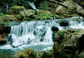
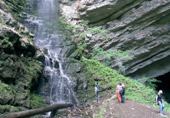
 Zeleni
vir is a karst cave with its source being the Curak stream. The
vertical rock (70 m) elevates between two steep wooded slopes, and
near the bottom stands a large cave opening. A waterfall comes down
the steep rock, up to the cave. The cave’s hall is spacious (about
30 m high), while in the other part there is a small green lake from
which Vir got its name (Zeleni vir, zeleni = green). From Munjara,
the path leads upstream to the entrance in Vražji prolaz. This is a
stone cutting among hundreds of meters of high rocks that may be
passed by means of galleries and small bridges cut into in the rock
and below the foamy and noisy Jasla stream. “It is a scenery
inspiring both the beauty and the atrocity of the savage karst
nature.” The path leads from one bridge to the other and the rocks
on both sides are so close to each other that just a trace of sky
can be discerned between them. Fifteen minutes later, the walk ends
with the entry to Mu eva hi ica (320 m). This cave ( 120 m long)
contains a lot of ponds and the temperature is stable (8oC). In the
entrance part, there are no dripstones, but deeper inside the cave
there are many of them (torches must be taken along).The path
continues with the ascent to the centre of Prezid. Flora: butterwort
(Pinguicula alpina), daisy of the Alps (Aster bellidiastrum)...
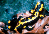
Fauna: spotted salamanders (Salamandra salamandra), many
invertebrates..
Zeleni
vir is a karst cave with its source being the Curak stream. The
vertical rock (70 m) elevates between two steep wooded slopes, and
near the bottom stands a large cave opening. A waterfall comes down
the steep rock, up to the cave. The cave’s hall is spacious (about
30 m high), while in the other part there is a small green lake from
which Vir got its name (Zeleni vir, zeleni = green). From Munjara,
the path leads upstream to the entrance in Vražji prolaz. This is a
stone cutting among hundreds of meters of high rocks that may be
passed by means of galleries and small bridges cut into in the rock
and below the foamy and noisy Jasla stream. “It is a scenery
inspiring both the beauty and the atrocity of the savage karst
nature.” The path leads from one bridge to the other and the rocks
on both sides are so close to each other that just a trace of sky
can be discerned between them. Fifteen minutes later, the walk ends
with the entry to Mu eva hi ica (320 m). This cave ( 120 m long)
contains a lot of ponds and the temperature is stable (8oC). In the
entrance part, there are no dripstones, but deeper inside the cave
there are many of them (torches must be taken along).The path
continues with the ascent to the centre of Prezid. Flora: butterwort
(Pinguicula alpina), daisy of the Alps (Aster bellidiastrum)...
Fauna: spotted salamanders (Salamandra salamandra), many
invertebrates..
Path to Skradski vrh
The climb to the the wooded Skradski vrh (1043 m) offers the
possibility to visit the Chapels of St. Mary’s Assumption Marijino
Uznesenje na Nebo (Holy Mass celebrated on 15th August) and
Kavranova stijena on which, according to the legend, ravens (raven =
gavran) used to nest. It offers a view of Skrad and the Jasle wood.
The descent on the other side is recommended - to the village of
Hribac and by the mountain road to Skrad. The Skrad promenade Three
Skrad promenades are the “official” ones, discover the other ones by
yourself. The Promenade «Pet klupa» (Five benches) is 500 metres
long, with no climbs, covered by juniper bushes The Promenade “Prema
Slemenu” (towards Sleme) starts in the village of Tusti Vrh and
heads to the village of Sleme. The promenade from the village of
Planina to Zeleni vir (traced in 1914) is some 1500 metres long.
|
|
Walking time:
- Skrad - Skradski vrh - Skrad 3 hours - Skrad - Zeleni vir 30 minutes - Skrad - Zeleni vir - Vražji prolaz - Skrad 2 hours and 30 minutes - Skrad - Zeleni vir - Vražji prolaz - Rogi – Kupica source - Kupjak 5 hours |
THE
DELNICE AREA
 The Town of Delnice, the Crni lug area and the Kupa Valley are three
units unveiling landscapes of extraordinary beauty and peculiarity
to visitors.The Delnice area offers the Risnjak National Park, the
Japlenški vrh wood, the protected area of Petehovac, the Kupa source
natural monument, the Kupa Valley, «kuća Rakči» - monument of
culture in Delnice, Hajdova spilja, and many other attractions.Its
uniqueness is further increased by the climatic-curative benefits
Delnice offers, the great number of Crni lug green meadows, the
«forecourt» of the Risnjak natural musuem, the picturesqueness of
the Kupa Valley (proposed for the category of park of nature). A
whole series of opportunities is provided to hikers and
mountaineers. From Delnice: through the promenades of kralj Tomislav
Park towards the town centre to kuća Rakči (the Rački house), an
easy climb to Japlenški vrh, to Polane, a somewhat higher climb to
Petehovac and Štimčev vrh, to Drgomalj, a walk through Supilova
street to the Delnice stream and the belvedere ingrlet. From Crni
Lug, one should pass towards Mali and Veliki Risnjak, to the Kupa
source from the village of Razloge, to Platak and Snježnik...The
Kupica source (M. Lesna), the path along Kupa and Kupica, walk to
Iševnica and along the Curak stream to Zeleni vir are scenic walks
in the Kupa Valley.
The Town of Delnice, the Crni lug area and the Kupa Valley are three
units unveiling landscapes of extraordinary beauty and peculiarity
to visitors.The Delnice area offers the Risnjak National Park, the
Japlenški vrh wood, the protected area of Petehovac, the Kupa source
natural monument, the Kupa Valley, «kuća Rakči» - monument of
culture in Delnice, Hajdova spilja, and many other attractions.Its
uniqueness is further increased by the climatic-curative benefits
Delnice offers, the great number of Crni lug green meadows, the
«forecourt» of the Risnjak natural musuem, the picturesqueness of
the Kupa Valley (proposed for the category of park of nature). A
whole series of opportunities is provided to hikers and
mountaineers. From Delnice: through the promenades of kralj Tomislav
Park towards the town centre to kuća Rakči (the Rački house), an
easy climb to Japlenški vrh, to Polane, a somewhat higher climb to
Petehovac and Štimčev vrh, to Drgomalj, a walk through Supilova
street to the Delnice stream and the belvedere ingrlet. From Crni
Lug, one should pass towards Mali and Veliki Risnjak, to the Kupa
source from the village of Razloge, to Platak and Snježnik...The
Kupica source (M. Lesna), the path along Kupa and Kupica, walk to
Iševnica and along the Curak stream to Zeleni vir are scenic walks
in the Kupa Valley.
We single out:
Easy mountain walks to Drgomalj
 The path towards this spacious highground is covered by a dense
wood, but also towards meadows with three peaks (Mali Drgomalj 1153
m, Veliki Drgomalj 1154 m and Stari Drgomalj 1051 m) starts from the
centre of Delnice. The beautiful view of Risnjak, Kupa and the
Slovene mountains as well as the pleasant strolling through the
gentle mountain scenery are the main reasons to embark on this
march. Hajdova hiža – only for the experienced and agile A special
adventure, not recommended to inexperienced mountain climbers, is
the visit to Hajdova hiža (725 m), the largest Gorski kotar cave. It
is 1300 metres long. The entrance gallery is 85m long, 27m wide and
16 m high. The descent to the cave is quite demanding.
The path towards this spacious highground is covered by a dense
wood, but also towards meadows with three peaks (Mali Drgomalj 1153
m, Veliki Drgomalj 1154 m and Stari Drgomalj 1051 m) starts from the
centre of Delnice. The beautiful view of Risnjak, Kupa and the
Slovene mountains as well as the pleasant strolling through the
gentle mountain scenery are the main reasons to embark on this
march. Hajdova hiža – only for the experienced and agile A special
adventure, not recommended to inexperienced mountain climbers, is
the visit to Hajdova hiža (725 m), the largest Gorski kotar cave. It
is 1300 metres long. The entrance gallery is 85m long, 27m wide and
16 m high. The descent to the cave is quite demanding.
Petehovac
First of all, Petehovac is a landscape of beautiful meadows, an
ideal climatic and sports-recreational area, and a pleasant ski
resort in winter. Mali Petehovac (1105 m) is the highest peak,
Petehovac is somewhat lower (1072 m), and Štimčev vrh (1024 m) is
the most popular destination.Japlenški vrh (842 m) can be reached
via a pleasant path starting in the Delnice park, intersected by
many tracks and paths. Here are the remains of the old ski jump from
which, in summer months, taps are sounded by trumpet to Delnice
dwellers and to the visitors.
|
|
Walk time:
- Delnice - Japlenški vrh one hour - Šetnica Kupica one hour - Delnice - Veliki Drgomalj 2 hours - Delnice - Petehovac one hour and 30 minutes - Delnice - Drgomalj - Velika Lešnica 6 hours - Mala Lešnica - Drgomalj 4 hours - Delnice - Drgomalj - Praprot - Razloge 6 hours |
|
|
Town of Delnice Tourism Office
phone 051/812 156 www.tz-delnice.hr tz-delnice@gorskikotar.com |
THE FUŽINE AREA
 The
settlement of Fužine (732 m), is situated above the Ličanka valley
sunken (1950) under the accumulation lake Bajer (0.5 km2). Its
history has been signed by the famous Gorski kotar road Karolinska
cesta (1725 - 1736), and the 130 years of Fužine tourist tradition
are emphasized with unhidden pride. The paths are the so-called
hiking and mountaineering tracks. The hiking tracks have special
names and are marked in a length exceeding 60 km. There are nine
tracks. Four of them (the tracks :Srce, Zaljubljenih, Ribička,
Djevojačka halja) are easy and non-demanding, and the remaining five
(Afrika, Jelenja, Lisija, Medveđa, Gorska vila) are more demanding.
They have been traced through Fužine, they touch or pass through
other places of the Fužine area as well, up to Benkovac (880 m) and
the St. Cross Chapel, overlooking the andesite pit to Lič (726 m)
and the spacious Ličkog polje (24km2, the flow of Ličanka in Ličko
polje has been proposed for the category of protected landscape),
the church of «Majka Božja Snježna» and of St. Juraj, to Vrata (780
m) and the smaller peaks and belvederes of Viljak (939 m), Grbantov
(juniper), Gorica (cyclamen), Preradovći (892 m), Tovići and
Špičunak, to Belo Selo (quality water source), up to Slavica Gornja
(870 m) and Donja (840 m)... They go around the Bajer Lake and
Lepenica (proposed for the category special reserves). They lead to
the excursion centre and the source of the river Ličanka, as well as
to the Vrelo cave. The mountain paths bear the name of the peak that
is their destination point. The departure point to these
destinations is the Fužine area itself for both littoral (Tuhobić,
1109 m and Zagradski vrh, 1187 m) and for predominantly mountaineous
destinations (Bitoraj, 1386 m, Viševica 1428 m). This is an area of
much diversity and of rich vegetation, but also of white limestone
formations (on Bitoraj) of unusual shape and with numerous
sink-holes, caves and views of exceptionally impressive scope and
beauty. The Bitoraj area has been nominated for the category of
significant landscape. In the Vrelo cave, 310 metres long, the
length of 230 metres, corresponding approximately to a twenty-minute
walk, has been arranged for sightseeing, in the course of which very
interesting dripstone ornaments can be seen and - due to its
horizontal position - this is the only Croatian cave that can also
be visited by those in wheelchairs. A special value of the cave is
its rich fauna. The cave has been nominated for protection in the
category of nature monuments.
The
settlement of Fužine (732 m), is situated above the Ličanka valley
sunken (1950) under the accumulation lake Bajer (0.5 km2). Its
history has been signed by the famous Gorski kotar road Karolinska
cesta (1725 - 1736), and the 130 years of Fužine tourist tradition
are emphasized with unhidden pride. The paths are the so-called
hiking and mountaineering tracks. The hiking tracks have special
names and are marked in a length exceeding 60 km. There are nine
tracks. Four of them (the tracks :Srce, Zaljubljenih, Ribička,
Djevojačka halja) are easy and non-demanding, and the remaining five
(Afrika, Jelenja, Lisija, Medveđa, Gorska vila) are more demanding.
They have been traced through Fužine, they touch or pass through
other places of the Fužine area as well, up to Benkovac (880 m) and
the St. Cross Chapel, overlooking the andesite pit to Lič (726 m)
and the spacious Ličkog polje (24km2, the flow of Ličanka in Ličko
polje has been proposed for the category of protected landscape),
the church of «Majka Božja Snježna» and of St. Juraj, to Vrata (780
m) and the smaller peaks and belvederes of Viljak (939 m), Grbantov
(juniper), Gorica (cyclamen), Preradovći (892 m), Tovići and
Špičunak, to Belo Selo (quality water source), up to Slavica Gornja
(870 m) and Donja (840 m)... They go around the Bajer Lake and
Lepenica (proposed for the category special reserves). They lead to
the excursion centre and the source of the river Ličanka, as well as
to the Vrelo cave. The mountain paths bear the name of the peak that
is their destination point. The departure point to these
destinations is the Fužine area itself for both littoral (Tuhobić,
1109 m and Zagradski vrh, 1187 m) and for predominantly mountaineous
destinations (Bitoraj, 1386 m, Viševica 1428 m). This is an area of
much diversity and of rich vegetation, but also of white limestone
formations (on Bitoraj) of unusual shape and with numerous
sink-holes, caves and views of exceptionally impressive scope and
beauty. The Bitoraj area has been nominated for the category of
significant landscape. In the Vrelo cave, 310 metres long, the
length of 230 metres, corresponding approximately to a twenty-minute
walk, has been arranged for sightseeing, in the course of which very
interesting dripstone ornaments can be seen and - due to its
horizontal position - this is the only Croatian cave that can also
be visited by those in wheelchairs. A special value of the cave is
its rich fauna. The cave has been nominated for protection in the
category of nature monuments.
|
|
We single out
the tracks: - Fužine - Preradovićev vrh 40 minutes - Fužine - Benkovac - Tuhobić 2 hours and 30 minutes - Vrata - pl. kuća Bitorajka - Bitoraj 2 hours and 45 minutes - Vrata - Javorje (10 km) – Bitoraj 1 hour and 30 minutes - Vrata - Javorje - Bukova kosa 14 km) – Viševica 40 minutes |
|
|
Fužine
Municipality Tourism Office phone 051/835 163 www.tzo-fuzine.hr tzo-fuzine@ri.t-com.hr |
Mountain cottages: Bitorajka (1303 m) about ten beds, water tank, personal sleeping bag is required
Habitat of edelweiss (Bitoraj), alder
(Alnus glutinosa) along the marshy water-flows. The autochtonous
stream trout (Salmo trutta m. fario) in the flows flowing into the
lakes. The valuable swampy areas of Ličko polje represent a special
botanic value! Valuable Bitoraj mountain flora: the endemic rock
cress species (Arabis scopoliana) and Athamanata haynaldii
THE MRKOPALJ MOUNTAIN PATH
 The
Mrkopalj area is a pleasant holiday resort and a Gorski kotar ski
resort. Mrkopalj (824 m), Begovo Razdolje (1078 m, the highest place
in Croatia), Tuk (875 m), Sunger (894 m), Brestova Draga and Bukovac
Sungerski are the centra l points of this area. “It is the cradle of
Croatian skiing”. In 1913 the first ski competition for Croatia and
Slovenia took place here and in 1934 the first Croatian ski jump was
built . The Norwegian Jan recorded his victory there (46 metreshigh
jump). At
The
Mrkopalj area is a pleasant holiday resort and a Gorski kotar ski
resort. Mrkopalj (824 m), Begovo Razdolje (1078 m, the highest place
in Croatia), Tuk (875 m), Sunger (894 m), Brestova Draga and Bukovac
Sungerski are the centra l points of this area. “It is the cradle of
Croatian skiing”. In 1913 the first ski competition for Croatia and
Slovenia took place here and in 1934 the first Croatian ski jump was
built . The Norwegian Jan recorded his victory there (46 metreshigh
jump). At
 the
foot of the wooded Velika Kapela and the highest Gorski kotar peak,
Bjelolasica (1533 m), in the spacious Mrkopaljsko polje, Vrbovsko
and the memorial Matić poljana (1030 m) are hidden monuments of
firstclass scientific but also aesthetic significance. The strict
reserve of Bijele and Samarske stijene, absolutely unparalleled, is
a genuine geormorphologic natural phenomenon offering a whole series
of peculiarities from plant and animal life. The Mrkopalj mountain
path - MPP - has been traced
the
foot of the wooded Velika Kapela and the highest Gorski kotar peak,
Bjelolasica (1533 m), in the spacious Mrkopaljsko polje, Vrbovsko
and the memorial Matić poljana (1030 m) are hidden monuments of
firstclass scientific but also aesthetic significance. The strict
reserve of Bijele and Samarske stijene, absolutely unparalleled, is
a genuine geormorphologic natural phenomenon offering a whole series
of peculiarities from plant and animal life. The Mrkopalj mountain
path - MPP - has been traced
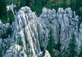 towards
the most beautiful parts of Samarske stijene, with eight control
stations that require a two day long walk (two traced circular
paths). Bijele and Samarske stijene are connected to the Kapela
mountain path, KPP, traced from Tuk to the sea coast in Klenovica.
The «karst-forms museum», Bijele (1335 m) and Samarske stijene (1302
m) separated by Crna and Duboka draga, are a unique manifestation of
nature in its most genuine form. Bijele stijene is the name for
numerous, vertical and up to fifty metres high
towards
the most beautiful parts of Samarske stijene, with eight control
stations that require a two day long walk (two traced circular
paths). Bijele and Samarske stijene are connected to the Kapela
mountain path, KPP, traced from Tuk to the sea coast in Klenovica.
The «karst-forms museum», Bijele (1335 m) and Samarske stijene (1302
m) separated by Crna and Duboka draga, are a unique manifestation of
nature in its most genuine form. Bijele stijene is the name for
numerous, vertical and up to fifty metres high
 differently
shaped rocks (kukovi, svodići, zubi, tornjići) and of deep, rugged
sink holes and precipices covered by everlasting snow.
differently
shaped rocks (kukovi, svodići, zubi, tornjići) and of deep, rugged
sink holes and precipices covered by everlasting snow.
The wood amongst the rocks is of the jungle type and beautiful,
small glades, the socalled «gardens» are some of their specific
features. The peak is a huge rock of vertical slopes wherefrom a
view extends on spires and steeples of the most unusual forms (a
peculiarity are the «big stone fingers»). Samarske stijene differ in
structure from Bijele stijene, and consist of some twenty massive
stone conical groups and forms sticking out above the surface of the
wood.
Here the strictest nature protection rules apply:
- nothing may be touched, picked up, or disturbed
- movements are strictly limited to the marked paths
- movement outside the path shall be considered a legal violation
- a permit has to be requested for each visit and research.
One can easily lose one’s way! Do not go alone.
|
|
Mountain
cottages and refuges: Refuge Ratkovo sklonište (1200 m) situated in a semicave below the cave Šerpas, 20 beds, water from the tank The mountain cottage Bijele stijene, 15 beds, water from the tank. |
Habitats :
- edelweiss (Leontopodium alpinum), groundsel (Senecio sp.), Great
leopard’s-bane (Doronicum austtiacum), a type of lily (Lilium
carniolicum), bears, wolves, foxes, badgers, black grouse, of the
endemic lizard
|
|
Walking time: Mličikov lug – refuge Ratkovo sklonište - Mličikov lug 2 hours Mličikov lug - Plana – top of Samarske stijene – refuge Ratkovo sklonište - Mličikov lug 3-4 hours Tuk - Matić poljana – top of Samarske stijene – refuge Ratkovo sklonište - Mličikov lug - Tuk 6-7 hours |
THE VRBOVSKO AREA
 On
the eastern part of Gorski kotar, above the river Dobra, caught
between the mountainsides of Velika Kapela, lies Vrbovsko (506 m).
Part of this area, in a semicircle from 8 to 15 km wide, are the
villages and hamlets of Gormirje (352 m), Severin na Kupi (200 m),
Lukovdol (180 m) and Moravice. This is a lower mountain area,
characterized by a milder and more stable climate, protected by
strong winds, with several fertile coves. The gentle areas of Jadrč,
Osojnik, Gomirje, Jablan, the natural monuments, castlepark (16th
century) of Severin na Kupi and the old yew-tree in Međedi, the
Čogrljino jezero lake in Tići but also the Church of St. Franjo
Ksaverski on Rtić (17th century), the memorial museum – the home of
the poet Ivan Goran Kovačić in Lukovdol, the monastery Ro denja St.
Jovana Preteče (17th century) in Gomirje, the molding workshop in
Plemenitaš, the peace and picturesqueness of the villages along the
Kupa, Zaumol, Bla evci are destinations that merit a visit. And yet,
owing to their peculiarity, the most prominent are the Kamačnik
canyon and the Lovnik – Litori mountain range. Kamačnik is a stream
cut out in the wooded northern slopes of Velika Kapela, wherefrom it
receives its tributaries only to become, some 3.2 kilometres
downstream, one of the Dobra affluents itself.
On
the eastern part of Gorski kotar, above the river Dobra, caught
between the mountainsides of Velika Kapela, lies Vrbovsko (506 m).
Part of this area, in a semicircle from 8 to 15 km wide, are the
villages and hamlets of Gormirje (352 m), Severin na Kupi (200 m),
Lukovdol (180 m) and Moravice. This is a lower mountain area,
characterized by a milder and more stable climate, protected by
strong winds, with several fertile coves. The gentle areas of Jadrč,
Osojnik, Gomirje, Jablan, the natural monuments, castlepark (16th
century) of Severin na Kupi and the old yew-tree in Međedi, the
Čogrljino jezero lake in Tići but also the Church of St. Franjo
Ksaverski on Rtić (17th century), the memorial museum – the home of
the poet Ivan Goran Kovačić in Lukovdol, the monastery Ro denja St.
Jovana Preteče (17th century) in Gomirje, the molding workshop in
Plemenitaš, the peace and picturesqueness of the villages along the
Kupa, Zaumol, Bla evci are destinations that merit a visit. And yet,
owing to their peculiarity, the most prominent are the Kamačnik
canyon and the Lovnik – Litori mountain range. Kamačnik is a stream
cut out in the wooded northern slopes of Velika Kapela, wherefrom it
receives its tributaries only to become, some 3.2 kilometres
downstream, one of the Dobra affluents itself.
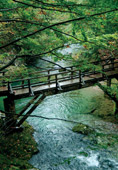
A protected landscape, this is an area that should be visited. The
attractive path, arranged (1961) and traced in the wooded area
upstream, along the stream itself, and cut out in the rocks, bridged
by small bridges and galleries, anticipates an impressive adventure.
The path leads to the stream’s source. It is a mighty Karst well
(405 m) forming a deep, dark green lake. Flora: a protected type of
laurel (Daphne laureola), soft butcher’s broom (Ruscus
hypoglossum)... Fauna: endemic underground small crab (Monolistra
sp.) , stream trout (Salmo trutta m. fario)
|
|
Walking time: - Vrbovsko - Kamačnik - Vrbovsko 2 hours and 30 minutes - Vrbovsko - Kamačnik - Bijela kosa - Kamačnik - Vrbovsko 6 hours and 30 minutes - Vrbovsko - Presika - Lovnik 2 hours and 30 minutes - Severin - Lukovdol - Gorenci – hunting lodge Litori 3 hours |
Lovnik - Litorić
The long mountain range, the only one in Gorski kotar not
reaching one thousand metres, is surrounded by the settlements of
Lukovdol, Moravice, Razdrto, Plemenitaš. There is no view from the
top of Lovnik (902 m); however, a beautiful view extends from the
climb near Hajdin - on Smolnik, Mirkovica with relay, Bijela and
Crna kosa.
Hunting lodges
Hunting lodge Kamačnik (519 m)
Hunting lodge pod Litoriće
|
|
Town of
Vrbovsko Tourism Office phone 051/875 984 www.tz-vrbovsko.hr turisticka.zajednica.grada.vrbovsko@ri.t-com.hr |
