
THE ISLAND OF LOŠINJ
Mali Lošinj, Veli Lošinj, Nerezine,
Ćunski
 To
be on holiday, listen and feel the sea, walk quietly in the shade of
pines and olive groves, that – and much more than that – is what the
Lošinj hiking tracks and promenades (suitable for all ages and
intended for a wide range of hikers) offer. Owing to its position,
mild climate and secular tourist tradition, Lošinj offers
opportunities of quality rest and recreation. Its
thalassotherapeutic effects the climate first of all, the air, sea
water, algae and vegetation are well known. Thus, as early as 1892,
Mali and Veli Lošinj were proclaimed climatic health resorts. It is
not easy to mention all the climatic benefits. Let us merely mention
that the average annual temperature is 15.3oC, the annual relative
humidity average is 70%, the average sea temperature in the winter
period is from 11.8oC and that there are 2561 hours of sunshine per
year. Among
To
be on holiday, listen and feel the sea, walk quietly in the shade of
pines and olive groves, that – and much more than that – is what the
Lošinj hiking tracks and promenades (suitable for all ages and
intended for a wide range of hikers) offer. Owing to its position,
mild climate and secular tourist tradition, Lošinj offers
opportunities of quality rest and recreation. Its
thalassotherapeutic effects the climate first of all, the air, sea
water, algae and vegetation are well known. Thus, as early as 1892,
Mali and Veli Lošinj were proclaimed climatic health resorts. It is
not easy to mention all the climatic benefits. Let us merely mention
that the average annual temperature is 15.3oC, the annual relative
humidity average is 70%, the average sea temperature in the winter
period is from 11.8oC and that there are 2561 hours of sunshine per
year. Among
 the
plant species the numerous seedlings of evergreen decorative and
other plants are here partly thanks to the Societies for
afforestation and embellishment of Mali and Veli Lošinj (under the
leadership of Ambroz Haračić) that operated in the 19h century. Here
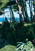
you can find agavas, Aleppo pine trees, cedar trees, hop hornbeam,
holly oaks, cypress, date palms, spruce, pine, strawberry trees,
carob, rosemary, tamarisk, laurel, magnolia. In addition, there are
many autochtonous herbs and edible plants. Their gorgeous fragrance
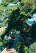
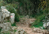
and flavour really must be felt and tasted. Numerous tracks and
promenades lead to the Lošinj natural attractions. The tracks lead
along the coast, but also across it, linking one side of the island
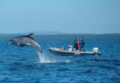
to the other. Walking along the seaside you may see and follow the
play of the dolphins, since a population of 150 dolphins, of the
dolphin species (Tursiops trancatus), lives in this area. They like
to approach the coast. Your promenade thus becomes also the
«dolphins’ path». Lošinj offers its promenades in three categories:
lungomare, easy and more demanding hiking tracks, and is also proud
of its mountain transversal Osorščica. Such a division has been made
exactly for the hikers since the mountain transversal only requires
good shape, while the difference between easier and more demanding
hiking tracks lies solely in the fact that demanding hiking tracks
include ascents on some of the Lošinj hills, but their height never
exceeds 240 metres. There are 150 km of marked tracks and promenades
in total. Old shepherds’ tracks have been arranged, special
arrangements offer hotel accommodation, the organization of special
walks and special gastronomic offerings.
the
plant species the numerous seedlings of evergreen decorative and
other plants are here partly thanks to the Societies for
afforestation and embellishment of Mali and Veli Lošinj (under the
leadership of Ambroz Haračić) that operated in the 19h century. Here
you can find agavas, Aleppo pine trees, cedar trees, hop hornbeam,
holly oaks, cypress, date palms, spruce, pine, strawberry trees,
carob, rosemary, tamarisk, laurel, magnolia. In addition, there are
many autochtonous herbs and edible plants. Their gorgeous fragrance
and flavour really must be felt and tasted. Numerous tracks and
promenades lead to the Lošinj natural attractions. The tracks lead
along the coast, but also across it, linking one side of the island
to the other. Walking along the seaside you may see and follow the
play of the dolphins, since a population of 150 dolphins, of the
dolphin species (Tursiops trancatus), lives in this area. They like
to approach the coast. Your promenade thus becomes also the
«dolphins’ path». Lošinj offers its promenades in three categories:
lungomare, easy and more demanding hiking tracks, and is also proud
of its mountain transversal Osorščica. Such a division has been made
exactly for the hikers since the mountain transversal only requires
good shape, while the difference between easier and more demanding
hiking tracks lies solely in the fact that demanding hiking tracks
include ascents on some of the Lošinj hills, but their height never
exceeds 240 metres. There are 150 km of marked tracks and promenades
in total. Old shepherds’ tracks have been arranged, special
arrangements offer hotel accommodation, the organization of special
walks and special gastronomic offerings.
LUNGOMARE
It follows the path along the coast, from the northeastern and the
northwestern Lošinj coast. The northeastern lungomare, turned to the
sea of the Lošinj channel, links Veli and Mali Lošinj, but extends
even further – from Veli Lošinj to the Kriško and Jamna Bays. On the
promenade linking these two places, there is a whole series of
picturesque bays - Jakovja, Valdrake, Bojčić, and one should not
forget to stop in the fishermen’s port of Rovenska and St. Martin.
Here are the origins of Mali Lošinj and its patron saint.
![]() Time
required (easy walk): three hours
Time
required (easy walk): three hours
Mali Lošinj - Veli Lošinj one hour
Mali Lošinj - St. Martin 30 minutes
The northwestern lungomare, open to the sea, towards the island of Susak has been traced through the famous area of Čikat, a protected wooded area. Boka Falsa, Zlatna, Srebrna, Sunčana uvala, Žalić (the pine tree – monument of park architecture) then Vela draga and Krivica are bays and destinations on this promenade. The promanades on Čikat bear the names of respectable and meritorious scientists: Dr. Leopold Ritter von Schrotter, Dr. Alfred Edler von Manussi and Dr. Conrad Clar. The Church Gospe od Navještenja, full of pictures of sailing vessels and prayers, should also be visited and an eye cast to the open sea – towards vessels and Lošinj sailors.
![]() Time
required (easy walk): two hours and 30 minutes
Time
required (easy walk): two hours and 30 minutes
Mali Lošinj - Čikat one hour and 30 minutes
Mali Lošinj - Sunčana uvala two hours and 30 minutes
 EASY
AND MORE DEMANDING HIKING TRACKS
EASY
AND MORE DEMANDING HIKING TRACKS
Linking one coast to the other, frequently passing through intact
nature, through olive groves and pine woods, these tracks lead to
single sacral buidings (St. Ivan, St. Nikola), climb on hills
wherefrom views of the whole island, and even further, extend.
Many people are of the opinion that, in order to get a better
view, one should climb on the mountain and the peak of St. John the
Baptist (St. Ivan Krstitelj). Here stand also the chapel (18th
century) on top of Kalvarija, at the height of 234m. Others might
prefer to climb Grgošćak, 242 metres high. There is a great number
of marked tracks, many are linked one to another, and almost all of
them to the lungomare. It is recommended to wear strong and
comfortable trainers or hiking boots on the tracks, especially on
the more demanding ones. It is advisable to bring water along. In
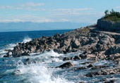
many places, the tracks are bordered on both sides by dry walls, the
so-called «gromače». They represent our oldest and permanent ethnic
architecture. Do take care of these walls and put any out of place
stones back in their place! You may come across lizards and
butterflies on your way, but you’ll never meet vipers. Like in Cres,
there are no vipers in Lošinj either. According to the legend, this
is owing to St. Gaudencije’s blessing. A recommended semi-demanding
track is: V. Lošinj - cape Korna – Balvanida Bay – Krivica Bay -
Sunčana uvala - Čikat Bay (about 6 hours)
![]() Time
required :
Time
required :
- easier: 20 to 30 minutes on average
- more demanding ones: one hour to one hour and a half on
average
 MOUNTAIN
TRANSVERSAL OSORŠICA
MOUNTAIN
TRANSVERSAL OSORŠICA
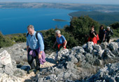
On the northern part of the island of Lošinj extends the ten
kilometre long Osoršica ridge , with its highest peak
Televrin (588m) that offers views of the Lošinj archipelago,
Istria, Velebit, right up to Rab, Pag and Gorski
kotar.
On a somewhat lower peak, St. Mikula (557m), are situated the small churches of St. Nikola and St. Ana. Each year on the Day of St. Ana (26th July), when the Holy Mass is celebrated, in the early morning hours a procession starts from Nerezine upwards. The easiest way to climb on Osorčica is across the path developed from Nerezine, to St. Mikula, proceeding to Televrin. At the height of 274 metres above sea level there is a mountain cottage. In 1887 the Tourist Society of Mali Lošinj, as a Section of Österreichischer Touristiklub, organized the march of the Austrian heir to the throne, Rudolf, to the top of Osoršćica.
We single out: Island of Susak, island Ilovik, Park -wood
Pod javori, Veli Lošinj
|
|
We recommend that you procure the prospectus-map Mali Lošinj – promenades and hiking tracks - Osoršica in which you can affix the stamp at the control stations ( 7 in total) |
|
|
Town of Mali
Lošinj Tourism Office phone 051/231 547 www.tz-malilosinj.hr tzg-mali-losinj@ri.t-com.hr |
